
This Photo Set provides photographic evidence of landmine casualties in Southeast Burma during the period from March 2021 to January 2024. Since February 2021, KHRG has received reports containing evidence of 69 landmine incidents in Southeast Burma affecting villagers, which resulted in at least 21 deaths and 68 people injured, including children. This Photo Set includes 27 photographs, from 17 of those incidents, showing injuries sustained by 15 villagers, including two children, and evidence on the death of six villagers, including one child. Of those 14 injured villagers, 8 had their legs amputated because of the severity of their injuries. The landmine explosions occurred in civilian areas, often in and around villages. The use of landmines by armed actors in civilian areas seriously impacts villagers’ security and livelihoods, as they increasingly fear the increasing threat of landmine contamination, affecting their security, freedom of movement and access to farmlands.
Photo Set | Landmine incidents in all seven districts of locally-defined Karen State (March 2021 to January 2024)
Since the 2021 coup[1], the use of landmines has proliferated in Southeast Burma amid the ongoing armed conflict. Landmines are used by not only the State Administration Council (SAC)[2], but all armed actors in Southeast Burma, to both protect territory and attack opponents. A lack of mine clearance operations has left severe contamination across Southeast Burma, of both new and old landmines. In addition, the SAC has been increasingly targeting civilians directly with these indiscriminate weapons.[3] Such use of landmines, and the overall contamination throughout the region, is causing civilian deaths and injuries and affecting the lives and livelihoods of villagers.
The following 27 photos were taken by community members in all seven districts of locally-defined Karen State[4], who have been trained by KHRG to monitor local human rights conditions in their areas, as well as other local villagers who provided their photos to KHRG. The districts are Doo Tha Htoo (Thaton), Taw Oo (Toungoo), Kler Lwee Htoo (Nyaunglebin), Mergui-Tavoy, Mu Traw (Hpapun), Dooplaya and Hpa-an.[5] The photographic evidence is presented below, censored where necessary for security purposes.
Further background reading on the situation of landmines, and overall human rights abuses, in Southeast Burma can be found in the following KHRG reports:
- KHRG, Danger Beneath Our Feet: Landmine contamination in Southeast Burma and its impacts on villagers since the 2021 coup, December 2023
- KHRG, Undeniable: War crimes, crimes against humanity and 30 years of villagers’ testimonies in rural Southeast Burma, December 2022.
- KHRG, Denied and Deprived: Local communities confronting the humanitarian crisis and protection challenges in Southeast Burma, June 2022.
Source:
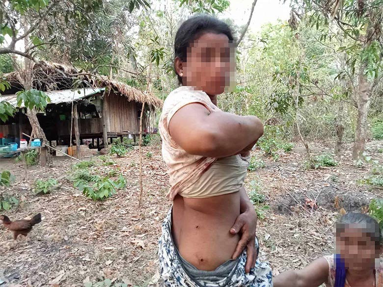


KHRG received these photos in April 2023. They show two villagers injured by a landmine explosion. On April 6th 2023, at about 3:30 pm, Naw[6] A--- (30 years old) and her daughter, Naw B--- (12 years old) from C--- village, Win Raw village tract[7], Tha Htoo (Thaton) Township, stepped on a landmine in a forest when they went to forage vegetables. The explosion injured them both: Naw A--- was injured on her hip and back, and Naw B--- was injured on her abdomen and legs. They sought treatment in a clinic in D--- village, run by the Karen National Union (KNU)[8]. It is unknown whether this landmine was planted by the SAC or the Karen National Liberation Army (KNLA)[9]. The incident happened in a place where both SAC and KNLA operated, and fighting between these armed groups often occurred in this area. [Photos: Local villager]


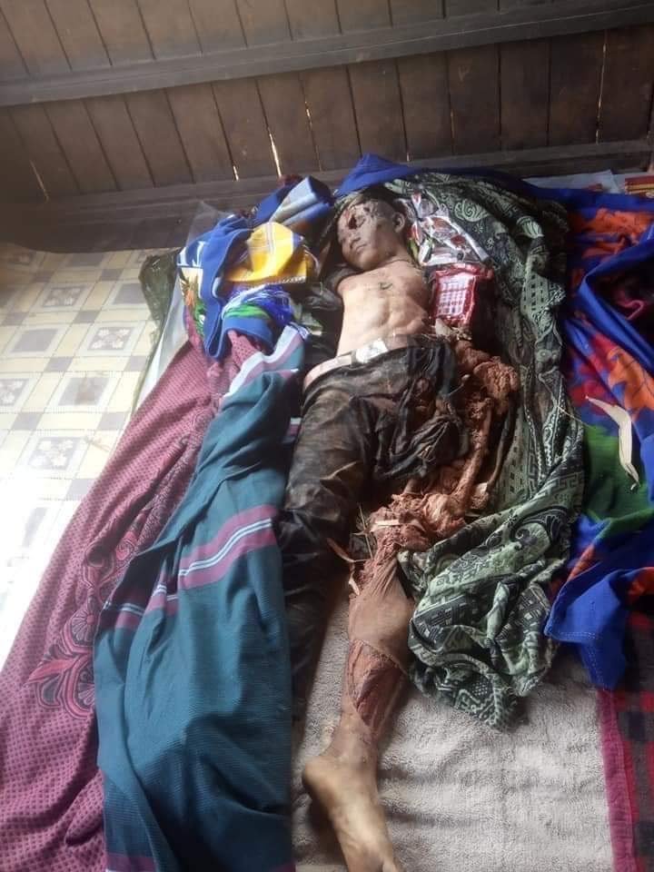
KHRG received these photos from a local villager on July 15th 2023. These photos were taken in E--- village, Ka Ywe village tract, Kyeh Htoh (Kyaikto) Township. They show the body of Maung[10] F---, a 13-year-old boy, who stepped on a landmine on July 13th 2023. The landmine had been planted by Pyu Saw Htee militia[11] soldiers living in the village, who are under the command of SAC Light Infantry Battalion (LIB)[12] #207 (which is under SAC Light Infantry Division (LID)[13] #44). He stepped on the landmine as he was going to look after his family’s cows as they grazed on pastures near the village. He died in the incident place from the injuries, without receiving emergency help as villagers confused the sound of the landmine explosion with the usual mortar shelling sounds heard in the area. His family members found his body the next morning after going to search for him, and organised the funeral without receiving any support or compensation from the SAC.[14] [Photos: Local villager]
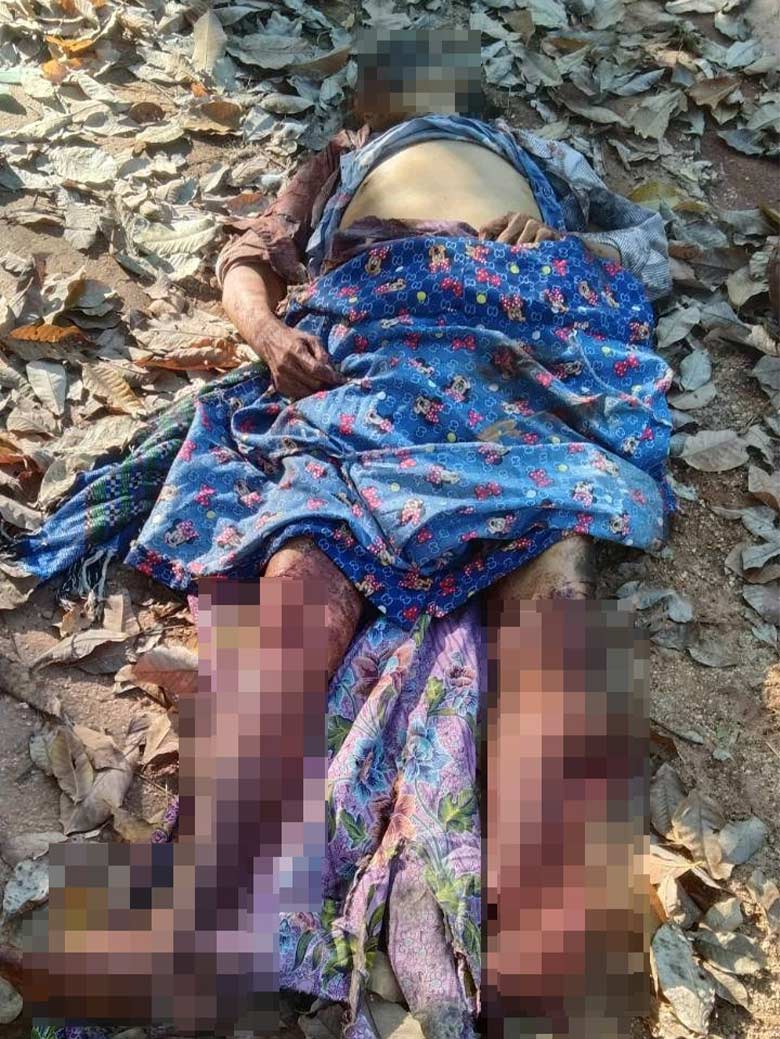


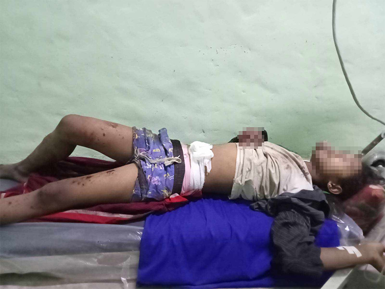
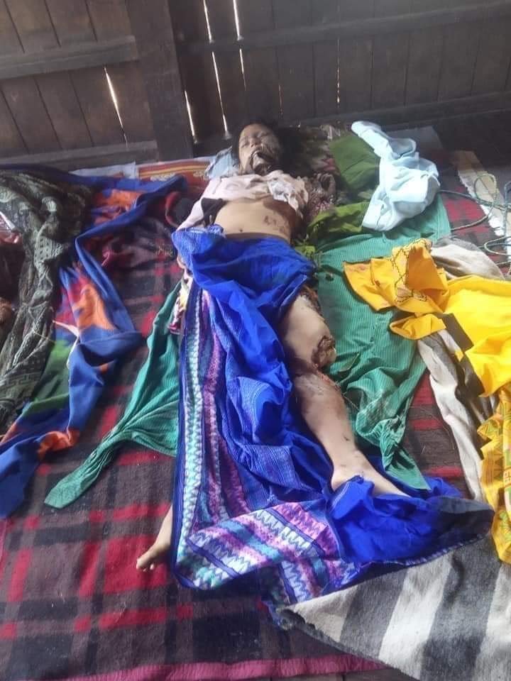
These photos were taken on January 13th 2023 in G--- village, Than Moe Taung village tract, Daw Hpa Hkoh (Thandaunggyi) Township. They show the body of Daw[15] Hkin Win, a 68-year-old villager, who was killed by a landmine on January 13th 2023. The explosion happened on Than Moe Taung road in G--- village when she was returning home from collecting wood nearby, and stepped on the landmine. Her left leg was completely blown off below the knee and she sustained severe injuries to her right leg, her left arm and her face. The landmine was planted by SAC troops following armed clashes in the area.[16] [Photos: Local villager]
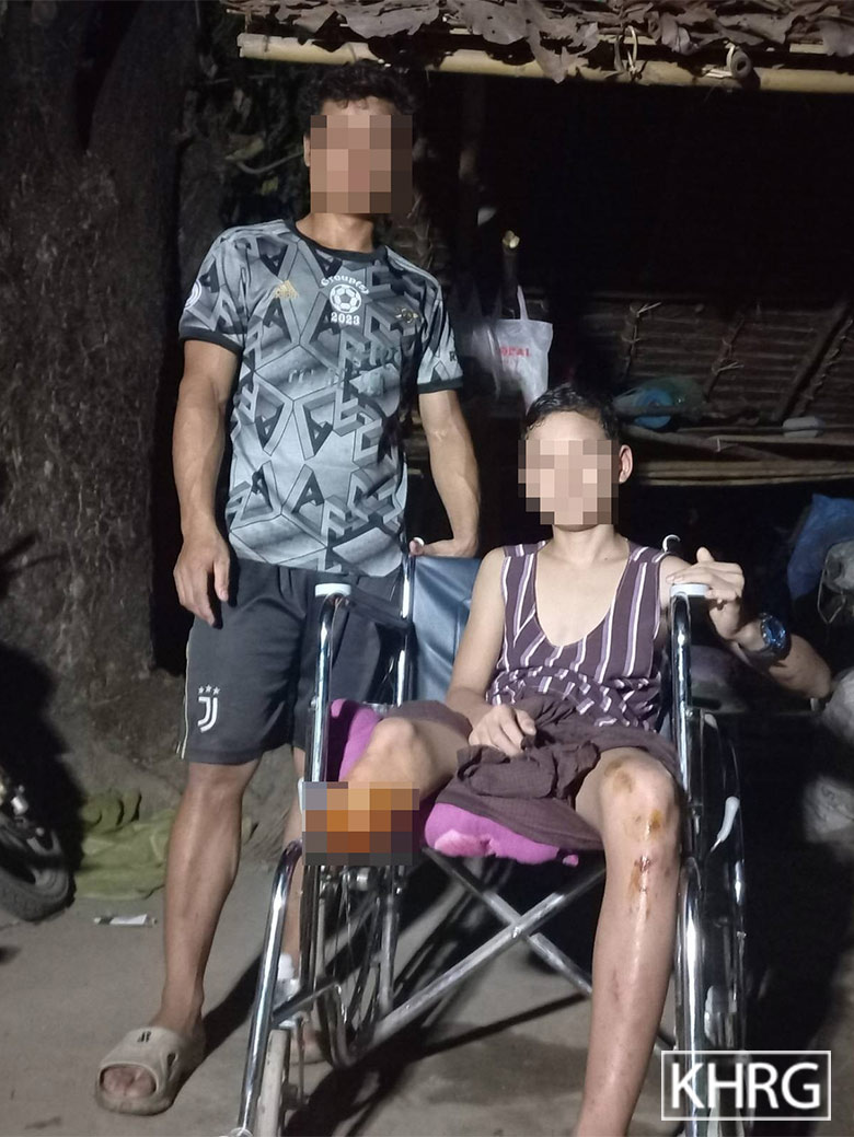
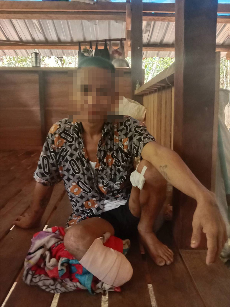
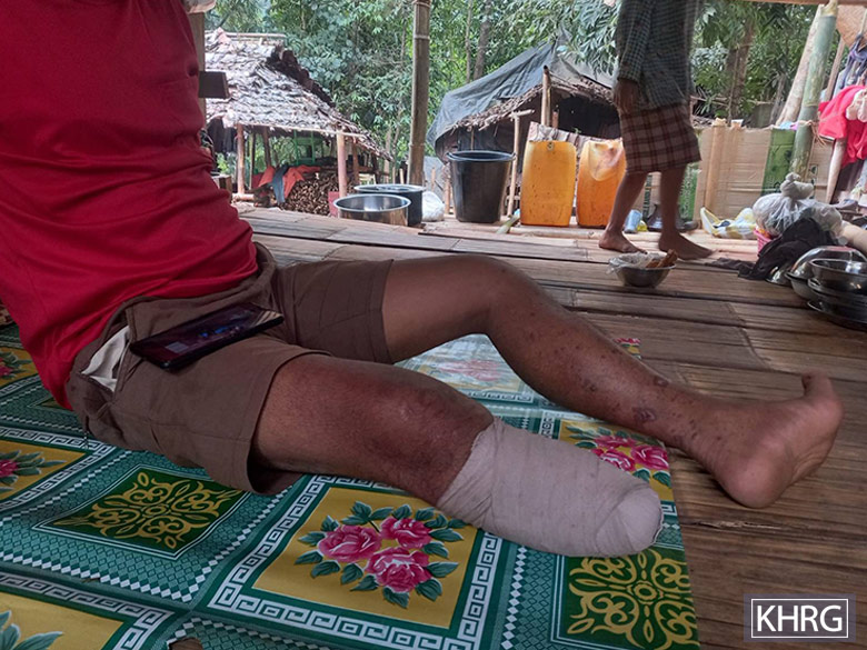
This photo was taken on May 6th 2023 in Af--- village, Daw Hpa Hkoh Township. It shows Saw[17] H--- and his brother, Saw I--- (13 years old), who is in a wheelchair having been seriously injured by a landmine. On March 22nd 2023, at 6 pm, Saw I--- stepped on a landmine when he went to fish in a river close to J--- village. He sustained serious injuries by the landmine explosion and his right leg had to be amputated. [Photo: KHRG]


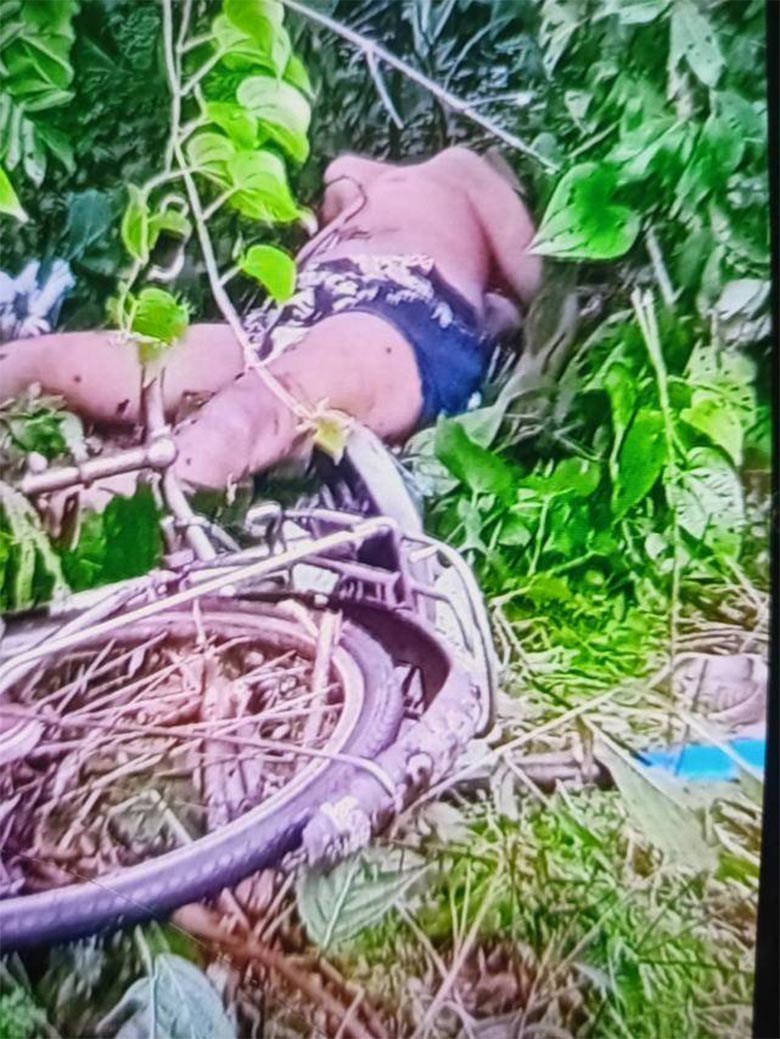
These photos were taken on March 1st 2021 in K--- village, Kheh Kah Hkoh village tract, Ler Doh (Kyaukkyi) Township. They show the bodies of two villagers who were killed by a landmine explosion. At 7:30 am on March 1st 2021, 24-year-old Saw L--- and 19-year-old Naw M---, from K--- village, were hit by a landmine explosion when they were travelling together to Ler Doh Town by motorbike to purchase goods for their shop. They were killed instantly by the explosion. Another villager travelled with them on another motorbike, Saw N--- (18 years old) and sustained minor injuries.[18] [Photos: Local villager]


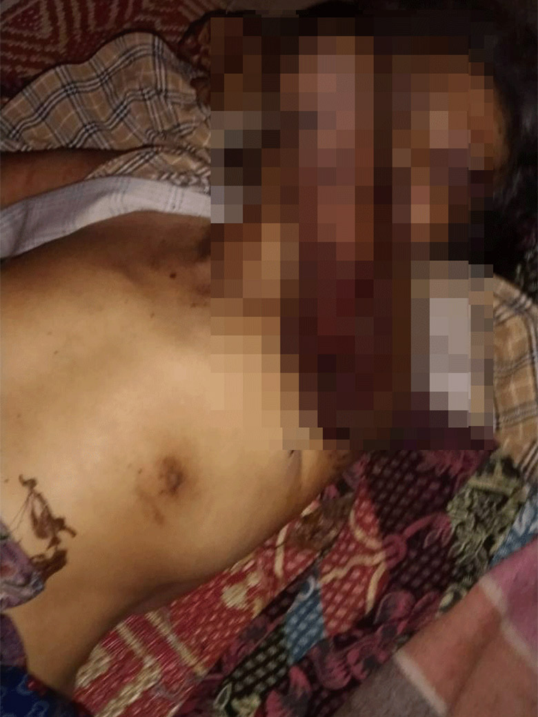
KHRG received these photos on February 4th 2023. On February 2nd 2023, a villager named Saw O--- from P--- village, Paw Pee Der village tract, Moo (Mone) Township, stepped on a landmine when he was travelling to his betel nut plantation in order to cut grass. He sustained injuries to his right leg and was sent to a hospital in Pyuh Town, Moo Township after the incident. KNLA Battalion #8, Company #3, from Brigade #3, planted this landmine in P--- village. These photos show Saw O--- injured, shortly after he stepped on the landmine. [Photos: Local villager]
KHRG received this photo from a local healthcare worker on August 6th 2023. It shows 45-year-old Saw Q--- receiving treatment for his wounds after being injured by a landmine explosion. He was treated in Law Ma Thaw hospital where he received treatment from Karen Department of Health and Welfare (KDHW)[19]. On August 4th 2023 at 6:30 am, Saw Q---, from R--- village, Th’Myit Aye Kone village tract, Ler Doh Township, stepped on a landmine when he was visiting S--- village. His left leg was blown off and his right leg was injured as well. Saw Q--- has a wife and five children. This landmine was planted by the KNLA. [Photo: KDHW]
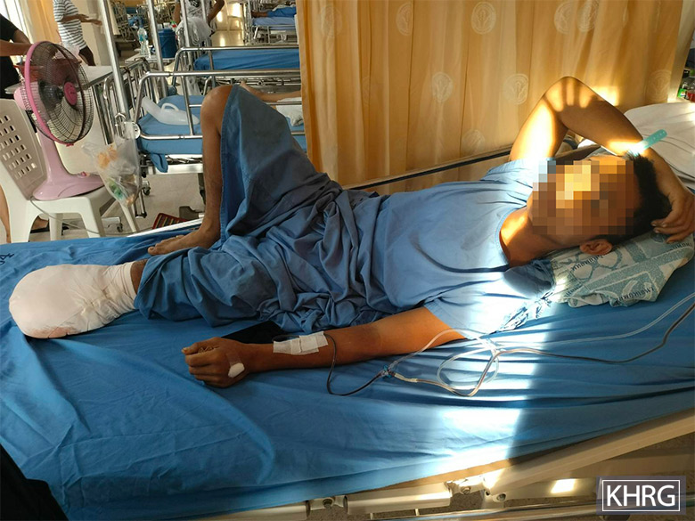
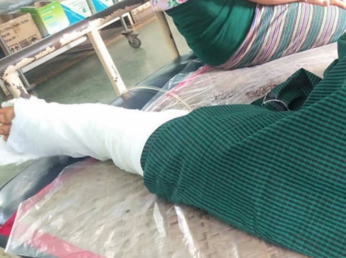
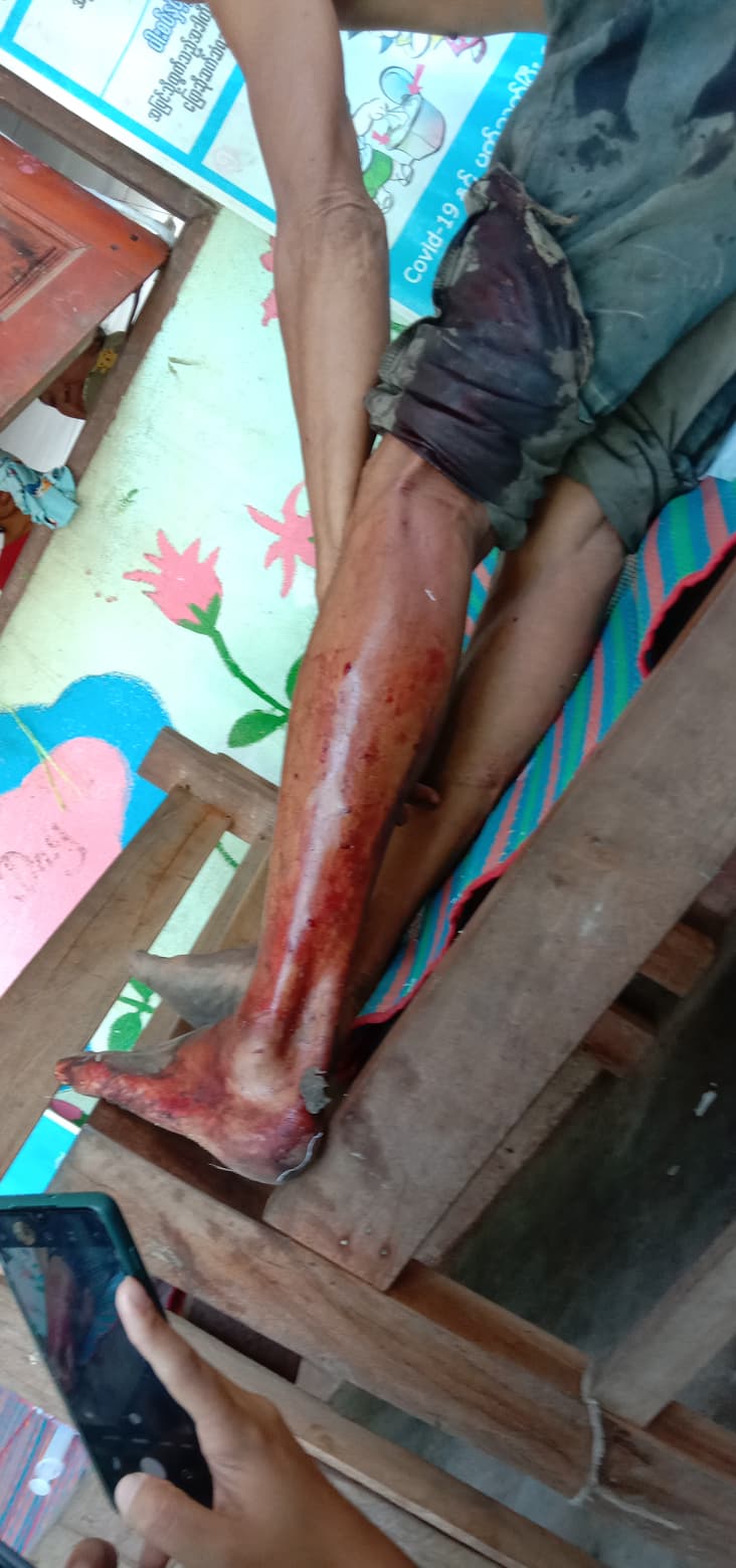
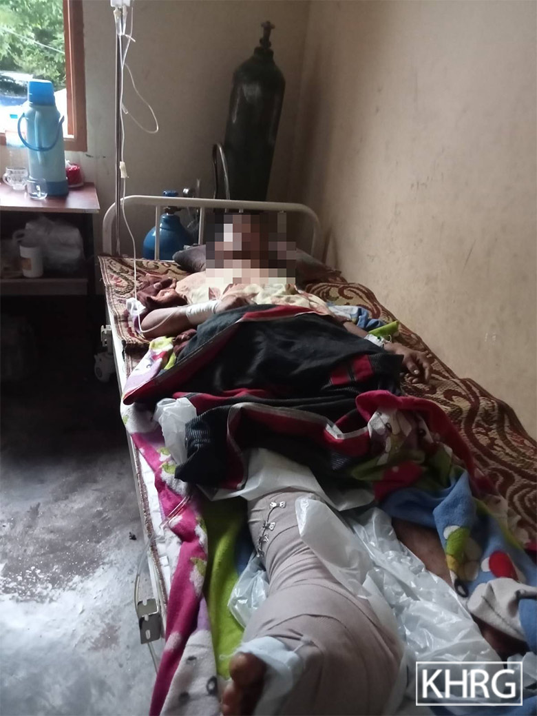
This photo was taken on October 16th 2023. It shows Saw T---, a 19-year-old villager from U--- village, Sa Tain village tract, Ler K’Hsaw Township, recovering in a hospital from injuries sustained by a landmine explosion. On October 15th 2023, Saw T--- was asked to accompany KNLA soldiers on a military operation in Ler K’Hsaw Township as he had some medical knowledge. During the operation, as Saw T--- was helping to carry the body of a KNLA soldier (who was killed by a sniper attack from the Kawthoolei Army (KTLA)[20]) to a KNU district office in the area, Saw T--- stepped on a landmine, at Yin Kweh Taung place, Hseh Phyu Taing village tract, K’Hser Doh Township, injuring his leg. He was taken for hospital treatment in K--- town, Thailand. His left leg had to be amputated due to the injuries sustained.[21] [Photo: KHRG]


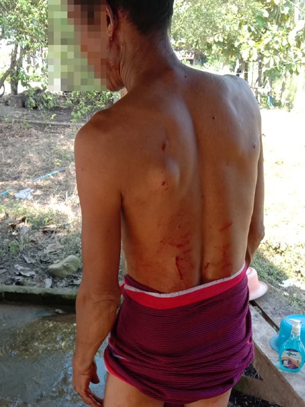
These photos show two villagers, W--- (32 years old) and X--- (55 years old) from Y--- village, Aur Naung Pat Kan village tract, Dwe Lo Township, being treated for injuries sustained after stepping on landmines near their village. On June 20th 2021, W--- stepped on a landmine while he was returning home from his hill fields. In a separate incident, on June 22nd 2021, X--- stepped on a landmine while she was harvesting mushrooms outside of her village. The photos above show X--- receiving treatment on June 24th 2021 in Mawlamyine Public Hospital. The photos below show W--- receiving treatment on June 20th 2021 in Hpa-an Public Hospital. In the case of both victims, their right legs had to be amputated because of their severe injuries. Villagers do not know which armed groups planted these two landmines.[22] [Photos: Local villager]
This photo was taken on January 9th 2022 in Z--- village, Meh Klaw village tract, Bu Tho Township. It shows a 55-year-old villager, Saw Aa---, shortly after he was seriously injured by a landmine explosion. Saw Aa--- was harvesting Daw Ka Tha (Oroxylum indicum, a type of flowering plant used in traditional medicine) to secure a livelihood for his family when he was injured by the landmine. Both of his legs were badly injured due to the landmine explosion. He was sent to the Military Operations Command (Byu Ha) Hospital in Hpapun Town. He passed away immediately after arriving at the hospital, without receiving treatment. [Photo: Local villager]
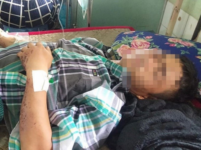
This photo was taken on May 29th 2022 of Saw Ab---, a 58-year-old villager from Ac--- village, Ler Muh Plaw village tract, Lu Thaw Township. On May 28th 2022 at 6 am, Saw Ab--- stepped on a landmine whilst travelling to his hill farmlands. The landmine had been planted by SAC soldiers from LIB #37. Saw Ab--- had lost his left leg back in 2011 from a landmine explosion, making this the second time he was injured by a landmine. In the most recent incident, he was injured on the same leg that had been amputated and sustained slight injuries on his other leg and his arms. The explosion damaged his prosthetic leg. He is now facing difficulties in earning a livelihood because of his injuries. He expressed his need of support from organisations that specifically provide aid to landmine victims. This photo shows Saw Ab--- recovering at a clinic from the injuries he sustained from the landmine explosion.[23] [Photo: KHRG]
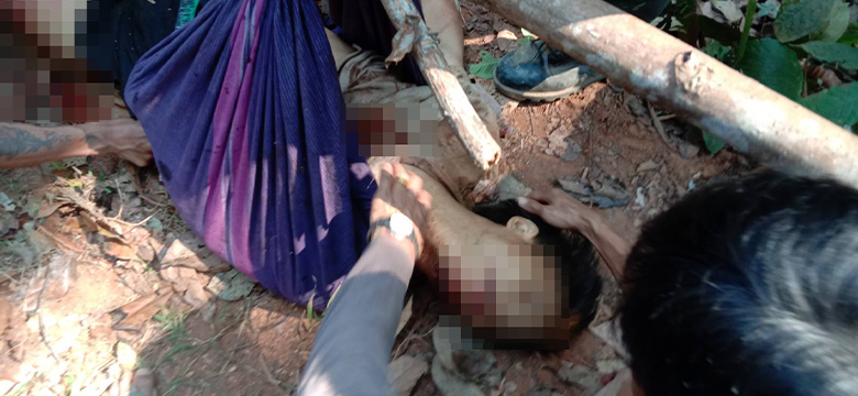


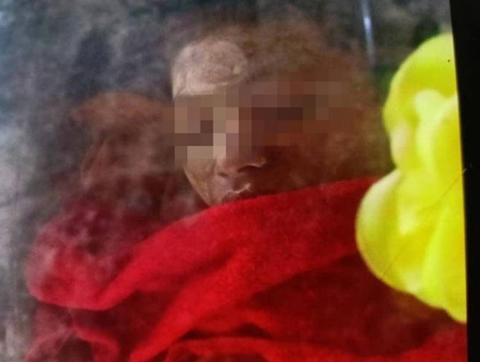
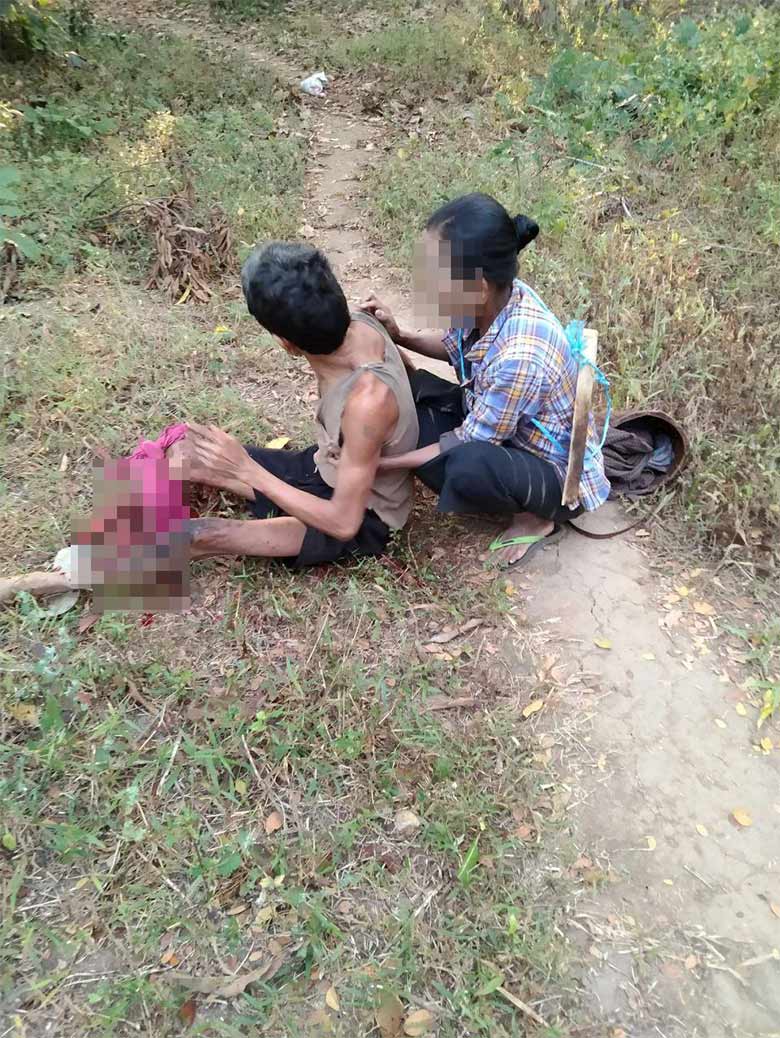
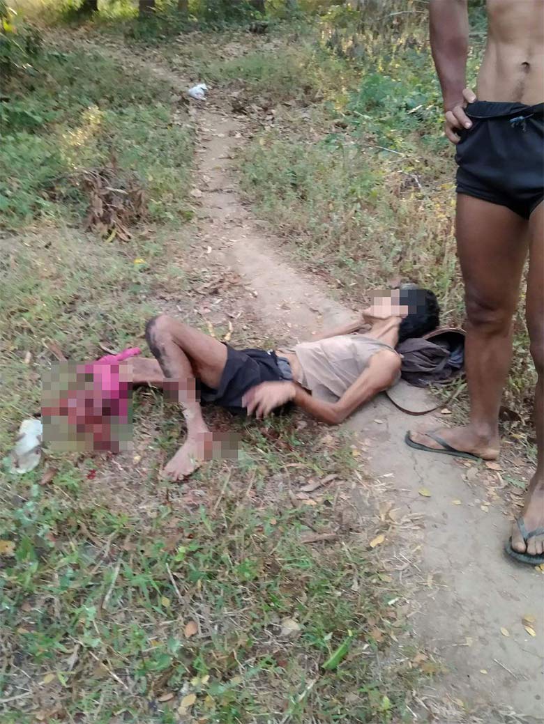
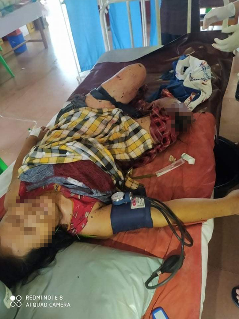
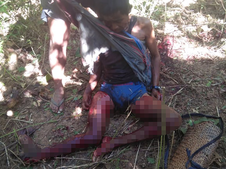
KHRG received these photos from on April 19th 2023. Saw Ag---, a 43-year-old villager from Ah--- village, Meh Way village tract, Dwe Lo Township, had been displaced to Ai--- village, Meh Way village tract with his family. On February 27th 2023 at 10 am, Saw Ag--- and his two children were returning to their home village to collect food when Saw Ag--- and his son, Saw Aj--- (18 years old), stepped on a landmine in a place next to Ah--- village. Saw Ag---’s right leg was blown off and his son was killed on the spot. Saw Ag--- received treatment for his injured leg at Ler Htoo Poe Hospital. The landmines were planted by KNLA Battalion #102 and although the KNU had informed villagers about contamination, Saw Ag--- and his sons were unaware of the landmines in this area. The photo on the left shows Saw Aj--- and the photo on the right shows Saw Ag---’s body. [Photos: Local villager]
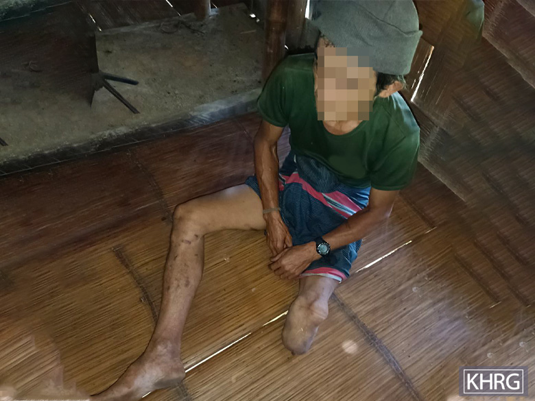
This photo was taken on January 24th 2024 and shows Saw Ad--- receiving medical treatment in Ae--- clinic, Ler Muh Plaw village tract, Lu Thaw Township. On January 24th 2024 at 9:45 am, Saw Ad---, a villager from Af--- village, Ler Muh Plaw village tract, stepped on a landmine when he was going to check his farm in Luh Kah Ber Khee area. His left leg was shattered from the landmine explosion. He was immediately sent to Ae--- clinic for medical treatment. The landmine was planted by SAC soldiers from an unknown battalion. He is married with two children and now faces challenges to sustain a livelihood for his family due to his injury. [Photo: KHRG]


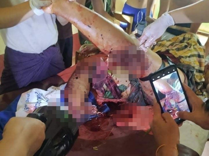
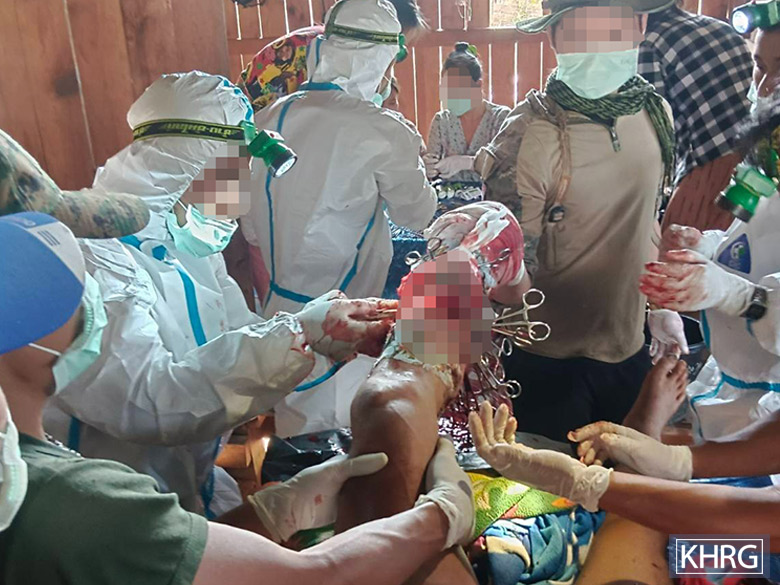
The three photos were taken on October 20th 2022 and show the injuries sustained by Ak--- from a tripwire landmine explosion in Al--- village, Maung Khee village tract, Kaw T’Ree (Kawkareik) Township, earlier that day. The first two photos show the injuries to his left ear and left leg, and the last photo below shows the injuries he sustained on his back. The tripwire landmine was assumed by villagers to have been set up by SAC military based at the Aung May K’Lar military camp. This incident occurred when Ak--- went to make charcoal beside the military camp, as he was returning to his kiln with wood he had collected in the forest close to the camp. He was sent to Waw Lay Hospital in Waw Lay Town, Kaw T’Ree Township, where he stayed for four days of treatment.[24] [Photos: Local villager]
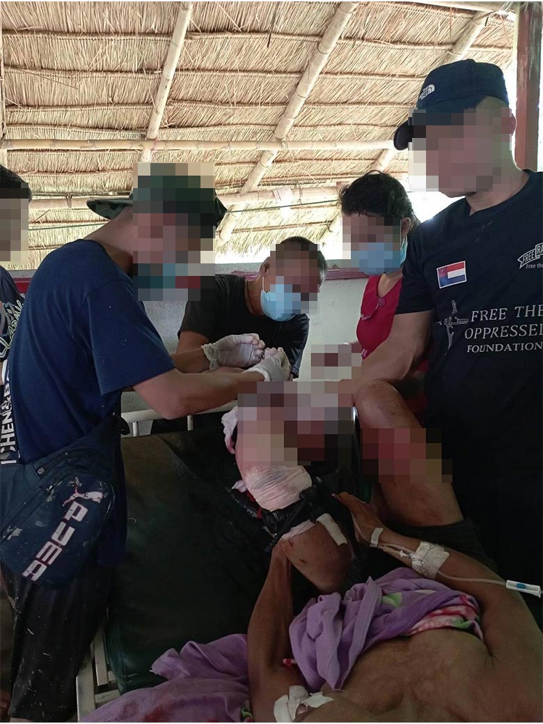
This photo was taken on January 9th 2024 in Am--- village, Taw Wah Law village tract, Kaw T’Ree Township. It shows Maung An---, a villager from Kyeikdon Town, Kaw T’Ree Township, whose right leg was amputated after a landmine explosion. On December 7th 2023, Maung An--- stepped on a landmine when he was returning to his house in Kyeikdon Town from a place where he was displaced. He fled from the town because the SAC LIB #558 fired mortar shells into the town in November 2023. He was seriously injured on his both legs. After the incident, he was sent to U--- Hospital, in Thailand, for medical treatment. Local villagers believe that this landmine was planted by SAC LIB #558. [Photo: KHRG]
This photo was taken on June 14th 2023, at Ao--- hospital, Ap--- village tract, Ta Kreh (Paingkyon) Township. It shows Saw Aq---, a 41-year-old villager from Ar--- village, Yaw Ku village tract, T’Nay Hsah Township, receiving medical treatment. On June 13th 2023, at around 2 pm, Saw Aq--- stepped on a landmine as he was going to the forest to collect some wild plants from a place near a deserted Democratic Karen Buddhist Army (DKBA)[25] army camp. His right foot was badly injured in the explosion. He received treatment at Ao---’s hospital, Pee T’Hka village tract, Ta Kreh Township.[26] [Photo: KHRG]
Footnotes:
[1] On February 1st 2021, the Burma Army deposed the democratically elected government led by the National League for Democracy (NLD), transferred power to Min Aung Hlaing, the Commander-in-Chief of Myanmar’s Armed Forces, and invalidated the NLD’s landslide victory in the November 2020 General Election.
[2] The State Administration Council (SAC) is the executive governing body created in the aftermath of the February 1st 2021 military coup. It was established by Senior General Min Aung Hlaing on February 2nd 2021, and is composed of eight military officers and eight civilians. The chairperson serves as the de facto head of government of Burma (Myanmar) and leads the Military Cabinet of Burma, the executive branch of the government.
[3] For more information on landmine incidents in Southeast Burma since the 2021 coup, see: KHRG: Danger Beneath Our Feet: Landmine contamination in Southeast Burma and its impacts on villagers since the 2021 coup, December 2023
[4] Karen State, located in Southeastern Burma, is primarily inhabited by ethnic Karen people. Most of the Karen population resides in the largely rural areas of Southeast Burma, living alongside other ethnic groups, including Bamar, Shan, Mon and Pa’Oh.
[5] KHRG operates in seven areas in Southeast Burma: Doo Tha Htoo (Thaton), Taw Oo (Toungoo), Kler Lwee Htoo (Nyaunglebin), Mergui-Tavoy, Mu Traw (Hpapun) and Dooplaya and Hpa-an. When KHRG receives information from the field, it organises data according to these seven areas. These are commonly referred to as ‘districts’ and are used by the Karen National Union (KNU), as well as many local Karen organisations, both those affiliated and unaffiliated with the KNU. KHRG’s use of the district designations in reference to our research areas does not imply political affiliation; rather, it is rooted in the fact that many rural communities commonly use these designations. For clarity, the Burmese terms for these districts are provided in brackets but do not correspond with the Burma (Myanmar) government administrative divisions.
[6] ‘Naw’ is a female honorific title in S’Gaw Karen language used before a person’s name.
[7] A village tract is an administrative unit of between five and 20 villages in a local area, often centred on a large village.
[8] The Karen National Union (KNU) is the main Karen political organisation. It was established in 1947 and has been in conflict with the Burma government since 1949. The KNU wields power across large areas of Southeast Burma and has been calling for the creation of a democratic federal system since 1976. Although it signed the Nationwide Ceasefire Agreement in 2015, relations with the government remained tense. Since the 2021 coup, it has been in open armed conflict with the State Administration Council (SAC).
[9] The Karen National Liberation Army is the armed wing of the Karen National Union.
[10] ‘Maung’ is a Burmese male honorific title used before a person’s name.
[11] The first Pyu Saw Htee groups were officially formed in mid-May 2021 in response to the National Unity Government’s call for the formalisation of a People’s Defence Force to resist the military regime following the 2021 military coup. The Pyu Saw Htee is made up of military veterans and Buddhist ultranationalist pro-military supporters whose aim is to counter and control opposition to the military regime.
[12] A Light Infantry Battalion (LIB) comprises 500 soldiers. Most Light Infantry Battalions in the Tatmadaw are under-strength with less than 200 soldiers, yet up-to-date information regarding the size of battalions is hard to come by, particularly following the signing of the NCA. LIBs are primarily used for offensive operations, but they are sometimes used for garrison duties.
[13] A Light Infantry Division (LID) of the Tatmadaw is commanded by a brigadier general, and consists of ten light infantry battalions specially trained in counter-insurgency, jungle warfare, search and destroy operations against ethnic insurgents. They were first incorporated into the Tatmadaw in 1966. LIDs are organised under three Tactical Operations Commands, commanded by a colonel, three battalions each and one reserve, one field artillery battalion, one armoured squadron and other support units. Each division is directly under the command of the Chief of Staff (Army).
[14] KHRG, “Doo Tha Htoo District Incident Report: A 13-year-old boy was killed by a landmine explosion in Kyeh Htoh Township, July 2023”, January 2024.
[15] ‘Daw’ is a Burmese female honorific title used before a person’s name.
[16] KHRG, “Taw Oo District Incident Report: A female villager died in a landmine explosion in Daw Hpa Hkoh Township, January 2023”, March 2023
[17] ‘Saw’ is a male honorific title in S’Gaw Karen language used before a person’s name.
[18] KHRG, “Kler Lwe Htoo District Incident Report: Two villagers killed, one injured in a landmine explosion in Ler Doh Township, March 2021”, April 2021
[19] The Karen Department of Health and Welfare (KDHW) is the health department of the Karen National Union. It was established in 1956 to address the lack of public healthcare resources in rural Southeast Myanmar. It currently operates a network of community-based clinics in the region, but its capabilities remain limited due to funding constraints.
[20] The Kaw Thoo Lei Army (KTLA) was founded on July 17th 2022 by Brigadier-General Nerdah Bo Mya. Nerdah Bo Mya, former Commander-In-Chief of the Karen National Defence Organisation (KNDO), was dismissed by the KNU in 2022. KTLA operates in two districts in Southeast Burma, in KNU-controlled areas, namely Mergui-Tavoy and Dooplaya districts. In Dooplaya District, they operate in alliance with resistance armed groups. KTLA battalions in Mergui-Tavoy District are in conflict with both SAC and KNLA troops.
[21] Unpublished report from Mergui-Tavoy District, received on December 2023.
[22] KHRG, “Mu Traw District Incident Report: Two villagers were seriously injured as a result of landmine explosions in Dwe Lo Township, Mu Traw District, June 2021”, July 2021
[23] KHRG, “Mu Traw District Incident Report: A villager from Ler Muh Plaw village tract, Lu Thaw Township was seriously injured by a landmine explosion, May 2022”, March 2023
[24] KHRG, “Dooplaya District Incident Report: A man was injured by a landmine explosion in Kaw T’Ree Township, October 2022”, January 2023
[25] The Democratic Karen Buddhist Army (DKBA) was originally formed in 1994 as a breakaway group from the Karen National Liberation Army (KNLA). Since its separation from the KNLA in 1994, it was known to frequently cooperate with and support the Tatmadaw in its conflict with the KNLA. The original group underwent major change in 2010 as the majority of the original DKBA was transformed into the Border Guard Force (BGF), which is under the control of the Burma/Myanmar government. The remainder of the original DKBA formed a smaller splinter group in 2010 and then changed its name in 2012 from the Democratic Karen Buddhist Army to the Democratic Karen Benevolent Army. Following this major change in 2010, the original DKBA is considered to no longer exist as a distinct entity as it has now been submerged within the BGF. This original DKBA (Buddhist) (1994 – 2010) should not be confused with either the DKBA (Benevolent) (2010 – present) which was formed as a breakaway group from the original DKBA, or with the DKBA (Buddhist) (2016 – present) which was formed as a splinter group from the DBKA (Benevolent) (2010 – present) in 2016. For more information on the formation of the DKBA, see “Inside the DKBA,” KHRG, 1996.
