
 ,
, 
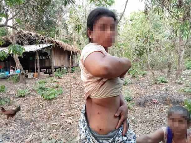
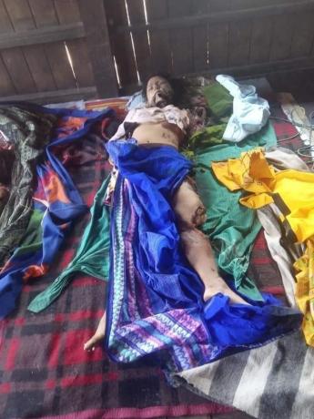
KHRG received these photos in April 2023. They show two villagers injured by a landmine explosion. On April 6th 2023, at about 3:30 pm, Naw[6] A--- (30 years old) and her daughter, Naw B--- (12 years old) from C--- village, Win Raw village tract[7], Tha Htoo (Thaton) Township, stepped on a landmine in a forest when they went to forage vegetables. The explosion injured them both: Naw A--- was injured on her hip and back, and Naw B--- was injured on her abdomen and legs. They sought treatment in a clinic in D--- village, run by the Karen National Union (KNU)[8]. It is unknown whether this landmine was planted by the SAC or the Karen National Liberation Army (KNLA)[9]. The incident happened in a place where both SAC and KNLA operated, and fighting between these armed groups often occurred in this area. [Photos: Local villager]
Photo Set | Landmine incidents in all seven districts of locally-defined Karen State (March 2021 to January 2024)
Since the 2021 coup[1], the use of landmines has proliferated in Southeast Burma amid the ongoing armed conflict. Landmines are used by not only the State Administration Council (SAC)[2], but all armed actors in Southeast Burma, to both protect territory and attack opponents. A lack of mine clearance operations has left severe contamination across Southeast Burma, of both new and old landmines. In addition, the SAC has been increasingly targeting civilians directly with these indiscriminate weapons.[3] Such use of landmines, and the overall contamination throughout the region, is causing civilian deaths and injuries and affecting the lives and livelihoods of villagers.
The following 27 photos were taken by community members in all seven districts of locally-defined Karen State[4], who have been trained by KHRG to monitor local human rights conditions in their areas, as well as other local villagers who provided their photos to KHRG. The districts are Doo Tha Htoo (Thaton), Taw Oo (Toungoo), Kler Lwee Htoo (Nyaunglebin), Mergui-Tavoy, Mu Traw (Hpapun), Dooplaya and Hpa-an.[5] The photographic evidence is presented below, censored where necessary for security purposes.
Further background reading on the situation of landmines, and overall human rights abuses, in Southeast Burma can be found in the following KHRG reports:
 ,
, 
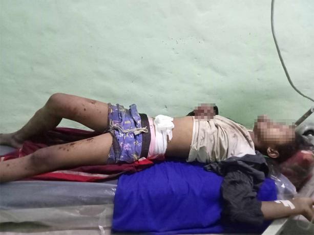
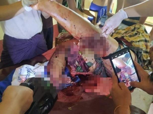
KHRG received these photos from a local villager on July 15th 2023. These photos were taken in E--- village, Ka Ywe village tract, Kyeh Htoh (Kyaikto) Township. They show the body of Maung[10] F---, a 13-year-old boy, who stepped on a landmine on July 13th 2023. The landmine had been planted by Pyu Saw Htee militia[11] soldiers living in the village, who are under the command of SAC Light Infantry Battalion (LIB)[12] #207 (which is under SAC Light Infantry Division (LID)[13] #44). He stepped on the landmine as he was going to look after his family’s cows as they grazed on pastures near the village. He died in the incident place from the injuries, without receiving emergency help as villagers confused the sound of the landmine explosion with the usual mortar shelling sounds heard in the area. His family members found his body the next morning after going to search for him, and organised the funeral without receiving any support or compensation from the SAC.[14] [Photos: Local villager]
Photo Set | Landmine incidents in all seven districts of locally-defined Karen State (March 2021 to January 2024)
Since the 2021 coup[1], the use of landmines has proliferated in Southeast Burma amid the ongoing armed conflict. Landmines are used by not only the State Administration Council (SAC)[2], but all armed actors in Southeast Burma, to both protect territory and attack opponents. A lack of mine clearance operations has left severe contamination across Southeast Burma, of both new and old landmines. In addition, the SAC has been increasingly targeting civilians directly with these indiscriminate weapons.[3] Such use of landmines, and the overall contamination throughout the region, is causing civilian deaths and injuries and affecting the lives and livelihoods of villagers.
The following 27 photos were taken by community members in all seven districts of locally-defined Karen State[4], who have been trained by KHRG to monitor local human rights conditions in their areas, as well as other local villagers who provided their photos to KHRG. The districts are Doo Tha Htoo (Thaton), Taw Oo (Toungoo), Kler Lwee Htoo (Nyaunglebin), Mergui-Tavoy, Mu Traw (Hpapun), Dooplaya and Hpa-an.[5] The photographic evidence is presented below, censored where necessary for security purposes.
Further background reading on the situation of landmines, and overall human rights abuses, in Southeast Burma can be found in the following KHRG reports:
 ,
, 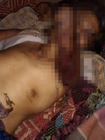
These photos were taken on January 13th 2023 in G--- village, Than Moe Taung village tract, Daw Hpa Hkoh (Thandaunggyi) Township. They show the body of Daw[15] Hkin Win, a 68-year-old villager, who was killed by a landmine on January 13th 2023. The explosion happened on Than Moe Taung road in G--- village when she was returning home from collecting wood nearby, and stepped on the landmine. Her left leg was completely blown off below the knee and she sustained severe injuries to her right leg, her left arm and her face. The landmine was planted by SAC troops following armed clashes in the area.[16] [Photos: Local villager]
Photo Set | Landmine incidents in all seven districts of locally-defined Karen State (March 2021 to January 2024)
Since the 2021 coup[1], the use of landmines has proliferated in Southeast Burma amid the ongoing armed conflict. Landmines are used by not only the State Administration Council (SAC)[2], but all armed actors in Southeast Burma, to both protect territory and attack opponents. A lack of mine clearance operations has left severe contamination across Southeast Burma, of both new and old landmines. In addition, the SAC has been increasingly targeting civilians directly with these indiscriminate weapons.[3] Such use of landmines, and the overall contamination throughout the region, is causing civilian deaths and injuries and affecting the lives and livelihoods of villagers.
The following 27 photos were taken by community members in all seven districts of locally-defined Karen State[4], who have been trained by KHRG to monitor local human rights conditions in their areas, as well as other local villagers who provided their photos to KHRG. The districts are Doo Tha Htoo (Thaton), Taw Oo (Toungoo), Kler Lwee Htoo (Nyaunglebin), Mergui-Tavoy, Mu Traw (Hpapun), Dooplaya and Hpa-an.[5] The photographic evidence is presented below, censored where necessary for security purposes.
Further background reading on the situation of landmines, and overall human rights abuses, in Southeast Burma can be found in the following KHRG reports:

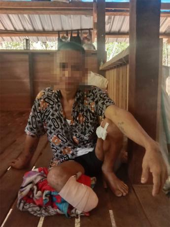
This photo was taken on May 6th 2023 in Af--- village, Daw Hpa Hkoh Township. It shows Saw[17] H--- and his brother, Saw I--- (13 years old), who is in a wheelchair having been seriously injured by a landmine. On March 22nd 2023, at 6 pm, Saw I--- stepped on a landmine when he went to fish in a river close to J--- village. He sustained serious injuries by the landmine explosion and his right leg had to be amputated. [Photo: KHRG]
Photo Set | Landmine incidents in all seven districts of locally-defined Karen State (March 2021 to January 2024)
Since the 2021 coup[1], the use of landmines has proliferated in Southeast Burma amid the ongoing armed conflict. Landmines are used by not only the State Administration Council (SAC)[2], but all armed actors in Southeast Burma, to both protect territory and attack opponents. A lack of mine clearance operations has left severe contamination across Southeast Burma, of both new and old landmines. In addition, the SAC has been increasingly targeting civilians directly with these indiscriminate weapons.[3] Such use of landmines, and the overall contamination throughout the region, is causing civilian deaths and injuries and affecting the lives and livelihoods of villagers.
The following 27 photos were taken by community members in all seven districts of locally-defined Karen State[4], who have been trained by KHRG to monitor local human rights conditions in their areas, as well as other local villagers who provided their photos to KHRG. The districts are Doo Tha Htoo (Thaton), Taw Oo (Toungoo), Kler Lwee Htoo (Nyaunglebin), Mergui-Tavoy, Mu Traw (Hpapun), Dooplaya and Hpa-an.[5] The photographic evidence is presented below, censored where necessary for security purposes.
Further background reading on the situation of landmines, and overall human rights abuses, in Southeast Burma can be found in the following KHRG reports:
 ,
, 
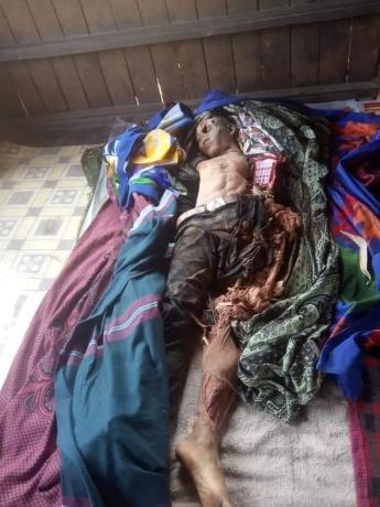
These photos were taken on March 1st 2021 in K--- village, Kheh Kah Hkoh village tract, Ler Doh (Kyaukkyi) Township. They show the bodies of two villagers who were killed by a landmine explosion. At 7:30 am on March 1st 2021, 24-year-old Saw L--- and 19-year-old Naw M---, from K--- village, were hit by a landmine explosion when they were travelling together to Ler Doh Town by motorbike to purchase goods for their shop. They were killed instantly by the explosion. Another villager travelled with them on another motorbike, Saw N--- (18 years old) and sustained minor injuries.[18] [Photos: Local villager]
Photo Set | Landmine incidents in all seven districts of locally-defined Karen State (March 2021 to January 2024)
Since the 2021 coup[1], the use of landmines has proliferated in Southeast Burma amid the ongoing armed conflict. Landmines are used by not only the State Administration Council (SAC)[2], but all armed actors in Southeast Burma, to both protect territory and attack opponents. A lack of mine clearance operations has left severe contamination across Southeast Burma, of both new and old landmines. In addition, the SAC has been increasingly targeting civilians directly with these indiscriminate weapons.[3] Such use of landmines, and the overall contamination throughout the region, is causing civilian deaths and injuries and affecting the lives and livelihoods of villagers.
The following 27 photos were taken by community members in all seven districts of locally-defined Karen State[4], who have been trained by KHRG to monitor local human rights conditions in their areas, as well as other local villagers who provided their photos to KHRG. The districts are Doo Tha Htoo (Thaton), Taw Oo (Toungoo), Kler Lwee Htoo (Nyaunglebin), Mergui-Tavoy, Mu Traw (Hpapun), Dooplaya and Hpa-an.[5] The photographic evidence is presented below, censored where necessary for security purposes.
Further background reading on the situation of landmines, and overall human rights abuses, in Southeast Burma can be found in the following KHRG reports:
 ,
, 
KHRG received these photos on February 4th 2023. On February 2nd 2023, a villager named Saw O--- from P--- village, Paw Pee Der village tract, Moo (Mone) Township, stepped on a landmine when he was travelling to his betel nut plantation in order to cut grass. He sustained injuries to his right leg and was sent to a hospital in Pyuh Town, Moo Township after the incident. KNLA Battalion #8, Company #3, from Brigade #3, planted this landmine in P--- village. These photos show Saw O--- injured, shortly after he stepped on the landmine. [Photos: Local villager]
Photo Set | Landmine incidents in all seven districts of locally-defined Karen State (March 2021 to January 2024)
Since the 2021 coup[1], the use of landmines has proliferated in Southeast Burma amid the ongoing armed conflict. Landmines are used by not only the State Administration Council (SAC)[2], but all armed actors in Southeast Burma, to both protect territory and attack opponents. A lack of mine clearance operations has left severe contamination across Southeast Burma, of both new and old landmines. In addition, the SAC has been increasingly targeting civilians directly with these indiscriminate weapons.[3] Such use of landmines, and the overall contamination throughout the region, is causing civilian deaths and injuries and affecting the lives and livelihoods of villagers.
The following 27 photos were taken by community members in all seven districts of locally-defined Karen State[4], who have been trained by KHRG to monitor local human rights conditions in their areas, as well as other local villagers who provided their photos to KHRG. The districts are Doo Tha Htoo (Thaton), Taw Oo (Toungoo), Kler Lwee Htoo (Nyaunglebin), Mergui-Tavoy, Mu Traw (Hpapun), Dooplaya and Hpa-an.[5] The photographic evidence is presented below, censored where necessary for security purposes.
Further background reading on the situation of landmines, and overall human rights abuses, in Southeast Burma can be found in the following KHRG reports:

KHRG received this photo from a local healthcare worker on August 6th 2023. It shows 45-year-old Saw Q--- receiving treatment for his wounds after being injured by a landmine explosion. He was treated in Law Ma Thaw hospital where he received treatment from Karen Department of Health and Welfare (KDHW)[19]. On August 4th 2023 at 6:30 am, Saw Q---, from R--- village, Th’Myit Aye Kone village tract, Ler Doh Township, stepped on a landmine when he was visiting S--- village. His left leg was blown off and his right leg was injured as well. Saw Q--- has a wife and five children. This landmine was planted by the KNLA. [Photo: KDHW]
Photo Set | Landmine incidents in all seven districts of locally-defined Karen State (March 2021 to January 2024)
Since the 2021 coup[1], the use of landmines has proliferated in Southeast Burma amid the ongoing armed conflict. Landmines are used by not only the State Administration Council (SAC)[2], but all armed actors in Southeast Burma, to both protect territory and attack opponents. A lack of mine clearance operations has left severe contamination across Southeast Burma, of both new and old landmines. In addition, the SAC has been increasingly targeting civilians directly with these indiscriminate weapons.[3] Such use of landmines, and the overall contamination throughout the region, is causing civilian deaths and injuries and affecting the lives and livelihoods of villagers.
The following 27 photos were taken by community members in all seven districts of locally-defined Karen State[4], who have been trained by KHRG to monitor local human rights conditions in their areas, as well as other local villagers who provided their photos to KHRG. The districts are Doo Tha Htoo (Thaton), Taw Oo (Toungoo), Kler Lwee Htoo (Nyaunglebin), Mergui-Tavoy, Mu Traw (Hpapun), Dooplaya and Hpa-an.[5] The photographic evidence is presented below, censored where necessary for security purposes.
Further background reading on the situation of landmines, and overall human rights abuses, in Southeast Burma can be found in the following KHRG reports:

This photo was taken on October 16th 2023. It shows Saw T---, a 19-year-old villager from U--- village, Sa Tain village tract, Ler K’Hsaw Township, recovering in a hospital from injuries sustained by a landmine explosion. On October 15th 2023, Saw T--- was asked to accompany KNLA soldiers on a military operation in Ler K’Hsaw Township as he had some medical knowledge. During the operation, as Saw T--- was helping to carry the body of a KNLA soldier (who was killed by a sniper attack from the Kawthoolei Army (KTLA)[20]) to a KNU district office in the area, Saw T--- stepped on a landmine, at Yin Kweh Taung place, Hseh Phyu Taing village tract, K’Hser Doh Township, injuring his leg. He was taken for hospital treatment in K--- town, Thailand. His left leg had to be amputated due to the injuries sustained.[21] [Photo: KHRG]
Photo Set | Landmine incidents in all seven districts of locally-defined Karen State (March 2021 to January 2024)
Since the 2021 coup[1], the use of landmines has proliferated in Southeast Burma amid the ongoing armed conflict. Landmines are used by not only the State Administration Council (SAC)[2], but all armed actors in Southeast Burma, to both protect territory and attack opponents. A lack of mine clearance operations has left severe contamination across Southeast Burma, of both new and old landmines. In addition, the SAC has been increasingly targeting civilians directly with these indiscriminate weapons.[3] Such use of landmines, and the overall contamination throughout the region, is causing civilian deaths and injuries and affecting the lives and livelihoods of villagers.
The following 27 photos were taken by community members in all seven districts of locally-defined Karen State[4], who have been trained by KHRG to monitor local human rights conditions in their areas, as well as other local villagers who provided their photos to KHRG. The districts are Doo Tha Htoo (Thaton), Taw Oo (Toungoo), Kler Lwee Htoo (Nyaunglebin), Mergui-Tavoy, Mu Traw (Hpapun), Dooplaya and Hpa-an.[5] The photographic evidence is presented below, censored where necessary for security purposes.
Further background reading on the situation of landmines, and overall human rights abuses, in Southeast Burma can be found in the following KHRG reports:
 ,
,  ,
,  ,
, 
These photos show two villagers, W--- (32 years old) and X--- (55 years old) from Y--- village, Aur Naung Pat Kan village tract, Dwe Lo Township, being treated for injuries sustained after stepping on landmines near their village. On June 20th 2021, W--- stepped on a landmine while he was returning home from his hill fields. In a separate incident, on June 22nd 2021, X--- stepped on a landmine while she was harvesting mushrooms outside of her village. The photos above show X--- receiving treatment on June 24th 2021 in Mawlamyine Public Hospital. The photos below show W--- receiving treatment on June 20th 2021 in Hpa-an Public Hospital. In the case of both victims, their right legs had to be amputated because of their severe injuries. Villagers do not know which armed groups planted these two landmines.[22] [Photos: Local villager]
Photo Set | Landmine incidents in all seven districts of locally-defined Karen State (March 2021 to January 2024)
Since the 2021 coup[1], the use of landmines has proliferated in Southeast Burma amid the ongoing armed conflict. Landmines are used by not only the State Administration Council (SAC)[2], but all armed actors in Southeast Burma, to both protect territory and attack opponents. A lack of mine clearance operations has left severe contamination across Southeast Burma, of both new and old landmines. In addition, the SAC has been increasingly targeting civilians directly with these indiscriminate weapons.[3] Such use of landmines, and the overall contamination throughout the region, is causing civilian deaths and injuries and affecting the lives and livelihoods of villagers.
The following 27 photos were taken by community members in all seven districts of locally-defined Karen State[4], who have been trained by KHRG to monitor local human rights conditions in their areas, as well as other local villagers who provided their photos to KHRG. The districts are Doo Tha Htoo (Thaton), Taw Oo (Toungoo), Kler Lwee Htoo (Nyaunglebin), Mergui-Tavoy, Mu Traw (Hpapun), Dooplaya and Hpa-an.[5] The photographic evidence is presented below, censored where necessary for security purposes.
Further background reading on the situation of landmines, and overall human rights abuses, in Southeast Burma can be found in the following KHRG reports:

This photo was taken on January 9th 2022 in Z--- village, Meh Klaw village tract, Bu Tho Township. It shows a 55-year-old villager, Saw Aa---, shortly after he was seriously injured by a landmine explosion. Saw Aa--- was harvesting Daw Ka Tha (Oroxylum indicum, a type of flowering plant used in traditional medicine) to secure a livelihood for his family when he was injured by the landmine. Both of his legs were badly injured due to the landmine explosion. He was sent to the Military Operations Command (Byu Ha) Hospital in Hpapun Town. He passed away immediately after arriving at the hospital, without receiving treatment. [Photo: Local villager]
Photo Set | Landmine incidents in all seven districts of locally-defined Karen State (March 2021 to January 2024)
Since the 2021 coup[1], the use of landmines has proliferated in Southeast Burma amid the ongoing armed conflict. Landmines are used by not only the State Administration Council (SAC)[2], but all armed actors in Southeast Burma, to both protect territory and attack opponents. A lack of mine clearance operations has left severe contamination across Southeast Burma, of both new and old landmines. In addition, the SAC has been increasingly targeting civilians directly with these indiscriminate weapons.[3] Such use of landmines, and the overall contamination throughout the region, is causing civilian deaths and injuries and affecting the lives and livelihoods of villagers.
The following 27 photos were taken by community members in all seven districts of locally-defined Karen State[4], who have been trained by KHRG to monitor local human rights conditions in their areas, as well as other local villagers who provided their photos to KHRG. The districts are Doo Tha Htoo (Thaton), Taw Oo (Toungoo), Kler Lwee Htoo (Nyaunglebin), Mergui-Tavoy, Mu Traw (Hpapun), Dooplaya and Hpa-an.[5] The photographic evidence is presented below, censored where necessary for security purposes.
Further background reading on the situation of landmines, and overall human rights abuses, in Southeast Burma can be found in the following KHRG reports:

This photo was taken on May 29th 2022 of Saw Ab---, a 58-year-old villager from Ac--- village, Ler Muh Plaw village tract, Lu Thaw Township. On May 28th 2022 at 6 am, Saw Ab--- stepped on a landmine whilst travelling to his hill farmlands. The landmine had been planted by SAC soldiers from LIB #37. Saw Ab--- had lost his left leg back in 2011 from a landmine explosion, making this the second time he was injured by a landmine. In the most recent incident, he was injured on the same leg that had been amputated and sustained slight injuries on his other leg and his arms. The explosion damaged his prosthetic leg. He is now facing difficulties in earning a livelihood because of his injuries. He expressed his need of support from organisations that specifically provide aid to landmine victims. This photo shows Saw Ab--- recovering at a clinic from the injuries he sustained from the landmine explosion.[23] [Photo: KHRG]
Photo Set | Landmine incidents in all seven districts of locally-defined Karen State (March 2021 to January 2024)
Since the 2021 coup[1], the use of landmines has proliferated in Southeast Burma amid the ongoing armed conflict. Landmines are used by not only the State Administration Council (SAC)[2], but all armed actors in Southeast Burma, to both protect territory and attack opponents. A lack of mine clearance operations has left severe contamination across Southeast Burma, of both new and old landmines. In addition, the SAC has been increasingly targeting civilians directly with these indiscriminate weapons.[3] Such use of landmines, and the overall contamination throughout the region, is causing civilian deaths and injuries and affecting the lives and livelihoods of villagers.
The following 27 photos were taken by community members in all seven districts of locally-defined Karen State[4], who have been trained by KHRG to monitor local human rights conditions in their areas, as well as other local villagers who provided their photos to KHRG. The districts are Doo Tha Htoo (Thaton), Taw Oo (Toungoo), Kler Lwee Htoo (Nyaunglebin), Mergui-Tavoy, Mu Traw (Hpapun), Dooplaya and Hpa-an.[5] The photographic evidence is presented below, censored where necessary for security purposes.
Further background reading on the situation of landmines, and overall human rights abuses, in Southeast Burma can be found in the following KHRG reports:
 ,
, 
KHRG received these photos from on April 19th 2023. Saw Ag---, a 43-year-old villager from Ah--- village, Meh Way village tract, Dwe Lo Township, had been displaced to Ai--- village, Meh Way village tract with his family. On February 27th 2023 at 10 am, Saw Ag--- and his two children were returning to their home village to collect food when Saw Ag--- and his son, Saw Aj--- (18 years old), stepped on a landmine in a place next to Ah--- village. Saw Ag---’s right leg was blown off and his son was killed on the spot. Saw Ag--- received treatment for his injured leg at Ler Htoo Poe Hospital. The landmines were planted by KNLA Battalion #102 and although the KNU had informed villagers about contamination, Saw Ag--- and his sons were unaware of the landmines in this area. The photo on the left shows Saw Aj--- and the photo on the right shows Saw Ag---’s body. [Photos: Local villager]
Photo Set | Landmine incidents in all seven districts of locally-defined Karen State (March 2021 to January 2024)
Since the 2021 coup[1], the use of landmines has proliferated in Southeast Burma amid the ongoing armed conflict. Landmines are used by not only the State Administration Council (SAC)[2], but all armed actors in Southeast Burma, to both protect territory and attack opponents. A lack of mine clearance operations has left severe contamination across Southeast Burma, of both new and old landmines. In addition, the SAC has been increasingly targeting civilians directly with these indiscriminate weapons.[3] Such use of landmines, and the overall contamination throughout the region, is causing civilian deaths and injuries and affecting the lives and livelihoods of villagers.
The following 27 photos were taken by community members in all seven districts of locally-defined Karen State[4], who have been trained by KHRG to monitor local human rights conditions in their areas, as well as other local villagers who provided their photos to KHRG. The districts are Doo Tha Htoo (Thaton), Taw Oo (Toungoo), Kler Lwee Htoo (Nyaunglebin), Mergui-Tavoy, Mu Traw (Hpapun), Dooplaya and Hpa-an.[5] The photographic evidence is presented below, censored where necessary for security purposes.
Further background reading on the situation of landmines, and overall human rights abuses, in Southeast Burma can be found in the following KHRG reports:

This photo was taken on January 24th 2024 and shows Saw Ad--- receiving medical treatment in Ae--- clinic, Ler Muh Plaw village tract, Lu Thaw Township. On January 24th 2024 at 9:45 am, Saw Ad---, a villager from Af--- village, Ler Muh Plaw village tract, stepped on a landmine when he was going to check his farm in Luh Kah Ber Khee area. His left leg was shattered from the landmine explosion. He was immediately sent to Ae--- clinic for medical treatment. The landmine was planted by SAC soldiers from an unknown battalion. He is married with two children and now faces challenges to sustain a livelihood for his family due to his injury. [Photo: KHRG]
Photo Set | Landmine incidents in all seven districts of locally-defined Karen State (March 2021 to January 2024)
Since the 2021 coup[1], the use of landmines has proliferated in Southeast Burma amid the ongoing armed conflict. Landmines are used by not only the State Administration Council (SAC)[2], but all armed actors in Southeast Burma, to both protect territory and attack opponents. A lack of mine clearance operations has left severe contamination across Southeast Burma, of both new and old landmines. In addition, the SAC has been increasingly targeting civilians directly with these indiscriminate weapons.[3] Such use of landmines, and the overall contamination throughout the region, is causing civilian deaths and injuries and affecting the lives and livelihoods of villagers.
The following 27 photos were taken by community members in all seven districts of locally-defined Karen State[4], who have been trained by KHRG to monitor local human rights conditions in their areas, as well as other local villagers who provided their photos to KHRG. The districts are Doo Tha Htoo (Thaton), Taw Oo (Toungoo), Kler Lwee Htoo (Nyaunglebin), Mergui-Tavoy, Mu Traw (Hpapun), Dooplaya and Hpa-an.[5] The photographic evidence is presented below, censored where necessary for security purposes.
Further background reading on the situation of landmines, and overall human rights abuses, in Southeast Burma can be found in the following KHRG reports:
 ,
,  ,
, 
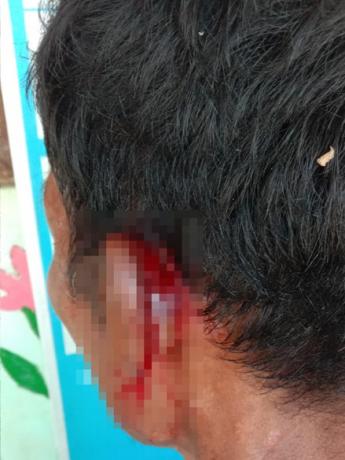
The three photos were taken on October 20th 2022 and show the injuries sustained by Ak--- from a tripwire landmine explosion in Al--- village, Maung Khee village tract, Kaw T’Ree (Kawkareik) Township, earlier that day. The first two photos show the injuries to his left ear and left leg, and the last photo below shows the injuries he sustained on his back. The tripwire landmine was assumed by villagers to have been set up by SAC military based at the Aung May K’Lar military camp. This incident occurred when Ak--- went to make charcoal beside the military camp, as he was returning to his kiln with wood he had collected in the forest close to the camp. He was sent to Waw Lay Hospital in Waw Lay Town, Kaw T’Ree Township, where he stayed for four days of treatment.[24] [Photos: Local villager]
Photo Set | Landmine incidents in all seven districts of locally-defined Karen State (March 2021 to January 2024)
Since the 2021 coup[1], the use of landmines has proliferated in Southeast Burma amid the ongoing armed conflict. Landmines are used by not only the State Administration Council (SAC)[2], but all armed actors in Southeast Burma, to both protect territory and attack opponents. A lack of mine clearance operations has left severe contamination across Southeast Burma, of both new and old landmines. In addition, the SAC has been increasingly targeting civilians directly with these indiscriminate weapons.[3] Such use of landmines, and the overall contamination throughout the region, is causing civilian deaths and injuries and affecting the lives and livelihoods of villagers.
The following 27 photos were taken by community members in all seven districts of locally-defined Karen State[4], who have been trained by KHRG to monitor local human rights conditions in their areas, as well as other local villagers who provided their photos to KHRG. The districts are Doo Tha Htoo (Thaton), Taw Oo (Toungoo), Kler Lwee Htoo (Nyaunglebin), Mergui-Tavoy, Mu Traw (Hpapun), Dooplaya and Hpa-an.[5] The photographic evidence is presented below, censored where necessary for security purposes.
Further background reading on the situation of landmines, and overall human rights abuses, in Southeast Burma can be found in the following KHRG reports:
This photo was taken on January 9th 2024 in Am--- village, Taw Wah Law village tract, Kaw T’Ree Township. It shows Maung An---, a villager from Kyeikdon Town, Kaw T’Ree Township, whose right leg was amputated after a landmine explosion. On December 7th 2023, Maung An--- stepped on a landmine when he was returning to his house in Kyeikdon Town from a place where he was displaced. He fled from the town because the SAC LIB #558 fired mortar shells into the town in November 2023. He was seriously injured on his both legs. After the incident, he was sent to U--- Hospital, in Thailand, for medical treatment. Local villagers believe that this landmine was planted by SAC LIB #558. [Photo: KHRG]
Photo Set | Landmine incidents in all seven districts of locally-defined Karen State (March 2021 to January 2024)
Since the 2021 coup[1], the use of landmines has proliferated in Southeast Burma amid the ongoing armed conflict. Landmines are used by not only the State Administration Council (SAC)[2], but all armed actors in Southeast Burma, to both protect territory and attack opponents. A lack of mine clearance operations has left severe contamination across Southeast Burma, of both new and old landmines. In addition, the SAC has been increasingly targeting civilians directly with these indiscriminate weapons.[3] Such use of landmines, and the overall contamination throughout the region, is causing civilian deaths and injuries and affecting the lives and livelihoods of villagers.
The following 27 photos were taken by community members in all seven districts of locally-defined Karen State[4], who have been trained by KHRG to monitor local human rights conditions in their areas, as well as other local villagers who provided their photos to KHRG. The districts are Doo Tha Htoo (Thaton), Taw Oo (Toungoo), Kler Lwee Htoo (Nyaunglebin), Mergui-Tavoy, Mu Traw (Hpapun), Dooplaya and Hpa-an.[5] The photographic evidence is presented below, censored where necessary for security purposes.
Further background reading on the situation of landmines, and overall human rights abuses, in Southeast Burma can be found in the following KHRG reports:

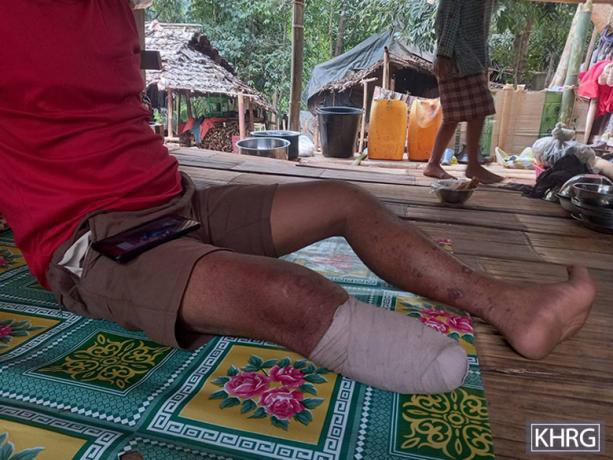
This photo was taken on June 14th 2023, at Ao--- hospital, Ap--- village tract, Ta Kreh (Paingkyon) Township. It shows Saw Aq---, a 41-year-old villager from Ar--- village, Yaw Ku village tract, T’Nay Hsah Township, receiving medical treatment. On June 13th 2023, at around 2 pm, Saw Aq--- stepped on a landmine as he was going to the forest to collect some wild plants from a place near a deserted Democratic Karen Buddhist Army (DKBA)[25] army camp. His right foot was badly injured in the explosion. He received treatment at Ao---’s hospital, Pee T’Hka village tract, Ta Kreh Township.[26] [Photo: KHRG]
Photo Set | Landmine incidents in all seven districts of locally-defined Karen State (March 2021 to January 2024)
Since the 2021 coup[1], the use of landmines has proliferated in Southeast Burma amid the ongoing armed conflict. Landmines are used by not only the State Administration Council (SAC)[2], but all armed actors in Southeast Burma, to both protect territory and attack opponents. A lack of mine clearance operations has left severe contamination across Southeast Burma, of both new and old landmines. In addition, the SAC has been increasingly targeting civilians directly with these indiscriminate weapons.[3] Such use of landmines, and the overall contamination throughout the region, is causing civilian deaths and injuries and affecting the lives and livelihoods of villagers.
The following 27 photos were taken by community members in all seven districts of locally-defined Karen State[4], who have been trained by KHRG to monitor local human rights conditions in their areas, as well as other local villagers who provided their photos to KHRG. The districts are Doo Tha Htoo (Thaton), Taw Oo (Toungoo), Kler Lwee Htoo (Nyaunglebin), Mergui-Tavoy, Mu Traw (Hpapun), Dooplaya and Hpa-an.[5] The photographic evidence is presented below, censored where necessary for security purposes.
Further background reading on the situation of landmines, and overall human rights abuses, in Southeast Burma can be found in the following KHRG reports: