

This photo was taken in February 2024 outside of Aa--- village, Ha Ta Reh (Lek) village tract[4], Hpa-an Township, Doo Tha Htoo District. The photo shows villagers, including children, from Aa--- village being displaced in a nearby forest, after the State Administration Council (SAC) carried out an air strike and strafed Aa--- village, on February 1st 2024, at 4:10 pm. [Photo: KHRG]
Photo Set: Air strike incidents resulting in death, injuries, destruction, and displacement, from January to December 2024
KHRG has received more than 1,142 photos of the destruction and harm caused by State Administration Council (SAC)[1] air strikes, from January to December 2024, in the seven districts of locally-defined Karen State[2]: Doo Tha Htoo (Thaton), Taw Oo (Toungoo), Kler Lwee Htoo (Nyaunglebin), Mergui-Tavoy, Mu Traw (Hpapun), Dooplaya, and Hpa-an districts. During 2021-June 2024, KHRG recorded 227 air strike incidents in Karen State, which killed at least 168 villagers and injured 249 others. Ninety-three of these incidents took place during January-June 2024 alone.[3]
In 2024, SAC soldiers conducted air strikes in the areas surrounding their army camps, in areas without fighting, and in areas outside of their control. A high number of air strikes were conducted on protected buildings such as those inside the compounds of medical clinics, churches, and schools, as well as villagers’ homes, farms, and plantations. This Photo Set includes 61 of these photos, as evidence of immediate and protracted impacts faced by local villagers in the aftermath of SAC air strikes in Southeast Burma. From the selection, 42 still photographs were taken by local community members trained by KHRG to monitor human rights conditions in their areas, and 19 were taken by local villagers.
Further background reading on the situation on attacks on livelihoods in Southeast Burma/Myanmar can be found in the following KHRG reports:
 ,
,  ,
, 
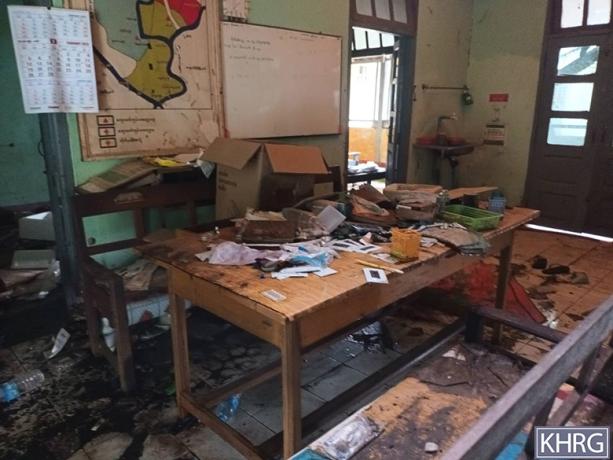
The two photos on the top were taken in March 2024, in Ab--- village, Khaw Hpoh Pleh village tract, Bilin Township, Doo Tha Htoo District. The photo on the left (top row) shows a school classroom that was destroyed after an SAC aircraft conducted an air strike on March 23rd 2024, shortly after 10 pm. The air strike destroyed all four school buildings in Ab--- village, and the school supplies. The village school was previously under Burma government administration, but it had been transferred to the Karen Education and Culture Department (KECD)[5] around two years before the attack. The photo on the right (top row) shows two houses owned by villagers that were destroyed by the air strike. The photo on the left (bottom row) was taken in April 2024 near Ab--- village and shows an unexploded bomb dropped by an SAC aircraft outside the village during the attack on March 23rd 2024. [Photos: KHRG]
Photo Set: Air strike incidents resulting in death, injuries, destruction, and displacement, from January to December 2024
KHRG has received more than 1,142 photos of the destruction and harm caused by State Administration Council (SAC)[1] air strikes, from January to December 2024, in the seven districts of locally-defined Karen State[2]: Doo Tha Htoo (Thaton), Taw Oo (Toungoo), Kler Lwee Htoo (Nyaunglebin), Mergui-Tavoy, Mu Traw (Hpapun), Dooplaya, and Hpa-an districts. During 2021-June 2024, KHRG recorded 227 air strike incidents in Karen State, which killed at least 168 villagers and injured 249 others. Ninety-three of these incidents took place during January-June 2024 alone.[3]
In 2024, SAC soldiers conducted air strikes in the areas surrounding their army camps, in areas without fighting, and in areas outside of their control. A high number of air strikes were conducted on protected buildings such as those inside the compounds of medical clinics, churches, and schools, as well as villagers’ homes, farms, and plantations. This Photo Set includes 61 of these photos, as evidence of immediate and protracted impacts faced by local villagers in the aftermath of SAC air strikes in Southeast Burma. From the selection, 42 still photographs were taken by local community members trained by KHRG to monitor human rights conditions in their areas, and 19 were taken by local villagers.
Further background reading on the situation on attacks on livelihoods in Southeast Burma/Myanmar can be found in the following KHRG reports:
 ,
, 
These photos were taken in April 2024 in Ac--- monastery in Meh Th’Na village tract, Hpa-an Township, Doo Tha Htoo District. These photos show an 85-year-old grandmother and her 12-year-old granddaughter who were injured by an SAC air strike conducted on the evening of April 20th 2024. Two small bombs hit the monastery in Ac--- village and injured them while they were hiding under some trees outside after they had heard an SAC aircraft conducting reconnaissance. The granddaughter was injured on her arm, and her grandmother was injured on her foot, losing three of her toes. [Photos: KHRG]
Photo Set: Air strike incidents resulting in death, injuries, destruction, and displacement, from January to December 2024
KHRG has received more than 1,142 photos of the destruction and harm caused by State Administration Council (SAC)[1] air strikes, from January to December 2024, in the seven districts of locally-defined Karen State[2]: Doo Tha Htoo (Thaton), Taw Oo (Toungoo), Kler Lwee Htoo (Nyaunglebin), Mergui-Tavoy, Mu Traw (Hpapun), Dooplaya, and Hpa-an districts. During 2021-June 2024, KHRG recorded 227 air strike incidents in Karen State, which killed at least 168 villagers and injured 249 others. Ninety-three of these incidents took place during January-June 2024 alone.[3]
In 2024, SAC soldiers conducted air strikes in the areas surrounding their army camps, in areas without fighting, and in areas outside of their control. A high number of air strikes were conducted on protected buildings such as those inside the compounds of medical clinics, churches, and schools, as well as villagers’ homes, farms, and plantations. This Photo Set includes 61 of these photos, as evidence of immediate and protracted impacts faced by local villagers in the aftermath of SAC air strikes in Southeast Burma. From the selection, 42 still photographs were taken by local community members trained by KHRG to monitor human rights conditions in their areas, and 19 were taken by local villagers.
Further background reading on the situation on attacks on livelihoods in Southeast Burma/Myanmar can be found in the following KHRG reports:
 ,
, 
These photos were taken in May 2024, in Ad--- village, Khaw Hpoh Pleh village tract, Bilin Township, Doo Tha Htoo District. The photos show one school (left photo) and one community hall (right photo) that were damaged by an SAC air strike during the night of April 29th 2024. The attack also damaged one other school, and 21 houses. The shrapnel from the bomb explosion also injured a 14-year-old girl. There was no fighting near the village prior to the attack. Many villagers from Ad--- village had already fled before the attack because the SAC had indiscriminately shelled nearby villages in the days leading up to the air strike. [Photos: KHRG]
Photo Set: Air strike incidents resulting in death, injuries, destruction, and displacement, from January to December 2024
KHRG has received more than 1,142 photos of the destruction and harm caused by State Administration Council (SAC)[1] air strikes, from January to December 2024, in the seven districts of locally-defined Karen State[2]: Doo Tha Htoo (Thaton), Taw Oo (Toungoo), Kler Lwee Htoo (Nyaunglebin), Mergui-Tavoy, Mu Traw (Hpapun), Dooplaya, and Hpa-an districts. During 2021-June 2024, KHRG recorded 227 air strike incidents in Karen State, which killed at least 168 villagers and injured 249 others. Ninety-three of these incidents took place during January-June 2024 alone.[3]
In 2024, SAC soldiers conducted air strikes in the areas surrounding their army camps, in areas without fighting, and in areas outside of their control. A high number of air strikes were conducted on protected buildings such as those inside the compounds of medical clinics, churches, and schools, as well as villagers’ homes, farms, and plantations. This Photo Set includes 61 of these photos, as evidence of immediate and protracted impacts faced by local villagers in the aftermath of SAC air strikes in Southeast Burma. From the selection, 42 still photographs were taken by local community members trained by KHRG to monitor human rights conditions in their areas, and 19 were taken by local villagers.
Further background reading on the situation on attacks on livelihoods in Southeast Burma/Myanmar can be found in the following KHRG reports:

The photo on the left was taken in January 2024, at 9 am, in Ae--- village, Day Loh Mu Nu village tract, Htaw Ta Htoo Township (Htantabin), Taw Oo District. The photo shows the inside of a house owned by a villager named A--- that was damaged by an SAC air strike on January 4th 2024. [Photo: KHRG]
Photo Set: Air strike incidents resulting in death, injuries, destruction, and displacement, from January to December 2024
KHRG has received more than 1,142 photos of the destruction and harm caused by State Administration Council (SAC)[1] air strikes, from January to December 2024, in the seven districts of locally-defined Karen State[2]: Doo Tha Htoo (Thaton), Taw Oo (Toungoo), Kler Lwee Htoo (Nyaunglebin), Mergui-Tavoy, Mu Traw (Hpapun), Dooplaya, and Hpa-an districts. During 2021-June 2024, KHRG recorded 227 air strike incidents in Karen State, which killed at least 168 villagers and injured 249 others. Ninety-three of these incidents took place during January-June 2024 alone.[3]
In 2024, SAC soldiers conducted air strikes in the areas surrounding their army camps, in areas without fighting, and in areas outside of their control. A high number of air strikes were conducted on protected buildings such as those inside the compounds of medical clinics, churches, and schools, as well as villagers’ homes, farms, and plantations. This Photo Set includes 61 of these photos, as evidence of immediate and protracted impacts faced by local villagers in the aftermath of SAC air strikes in Southeast Burma. From the selection, 42 still photographs were taken by local community members trained by KHRG to monitor human rights conditions in their areas, and 19 were taken by local villagers.
Further background reading on the situation on attacks on livelihoods in Southeast Burma/Myanmar can be found in the following KHRG reports:
 ,
, 
These photos were received on February 4th 2024, from a villager from Af--- village, Ha Thet Poe Le area, Daw Hpa Hkoh (Thandaunggyi) Township, Taw Oo District. On February 1st 2024, at 10:30 pm, three SAC fighter jets conducted an air strike on Af--- village, damaging 14 houses, a church, and school buildings. The photo on the right shows a house owned by a villager that was destroyed, and the photo on the left shows the church that was also damaged by the attack. Before the air strike, SAC soldiers from Ba Yin Naung army camp, in Daw Hpah Hkoh (Thandaunggyi) Town, SAC soldiers from Light Infantry Battalion (LIB)[6] #603, based in Leik Tho Town, and SAC soldiers from Shway Nan Ka Lay Operations army camp, led by Commander Ha Lin Aung, all fired mortar shells into the village and injured one villager. After that, three SAC fighter jets carried out reconnaissance over Af--- village and then conducted air strikes. The attack also damaged a building outside the village where Karen National Liberation Army (KNLA)[7] and People’s Defence Force (PDF)[8] troops were staying. [Photos: Local villagers]
Photo Set: Air strike incidents resulting in death, injuries, destruction, and displacement, from January to December 2024
KHRG has received more than 1,142 photos of the destruction and harm caused by State Administration Council (SAC)[1] air strikes, from January to December 2024, in the seven districts of locally-defined Karen State[2]: Doo Tha Htoo (Thaton), Taw Oo (Toungoo), Kler Lwee Htoo (Nyaunglebin), Mergui-Tavoy, Mu Traw (Hpapun), Dooplaya, and Hpa-an districts. During 2021-June 2024, KHRG recorded 227 air strike incidents in Karen State, which killed at least 168 villagers and injured 249 others. Ninety-three of these incidents took place during January-June 2024 alone.[3]
In 2024, SAC soldiers conducted air strikes in the areas surrounding their army camps, in areas without fighting, and in areas outside of their control. A high number of air strikes were conducted on protected buildings such as those inside the compounds of medical clinics, churches, and schools, as well as villagers’ homes, farms, and plantations. This Photo Set includes 61 of these photos, as evidence of immediate and protracted impacts faced by local villagers in the aftermath of SAC air strikes in Southeast Burma. From the selection, 42 still photographs were taken by local community members trained by KHRG to monitor human rights conditions in their areas, and 19 were taken by local villagers.
Further background reading on the situation on attacks on livelihoods in Southeast Burma/Myanmar can be found in the following KHRG reports:
 ,
,  ,
, 
These three photos were received from a local villager on February 21st 2024. The two photos in the top row show two children who were injured by an SAC air strike and helicopter attack on February 21st 2024, at around 2 pm, in Ag--- village, Pa Tauk Kone village tract, Daw Hpa Hkoh Township, Taw Oo District. The air strike injured two of the children’s adult family members and killed one other family member. The photo on the left shows the house of the family, destroyed by the air strike. The attack killed some of the family’s livestock and also damaged a water pot. At 2:15 pm, an SAC aircraft conducted air strikes again on Ag--- village, killing three more villagers and injuring five other villagers. There had been no fighting or armed forces’ movement in or near the village since the first quarter of 2023.[9] [Photos: Local villagers]
Photo Set: Air strike incidents resulting in death, injuries, destruction, and displacement, from January to December 2024
KHRG has received more than 1,142 photos of the destruction and harm caused by State Administration Council (SAC)[1] air strikes, from January to December 2024, in the seven districts of locally-defined Karen State[2]: Doo Tha Htoo (Thaton), Taw Oo (Toungoo), Kler Lwee Htoo (Nyaunglebin), Mergui-Tavoy, Mu Traw (Hpapun), Dooplaya, and Hpa-an districts. During 2021-June 2024, KHRG recorded 227 air strike incidents in Karen State, which killed at least 168 villagers and injured 249 others. Ninety-three of these incidents took place during January-June 2024 alone.[3]
In 2024, SAC soldiers conducted air strikes in the areas surrounding their army camps, in areas without fighting, and in areas outside of their control. A high number of air strikes were conducted on protected buildings such as those inside the compounds of medical clinics, churches, and schools, as well as villagers’ homes, farms, and plantations. This Photo Set includes 61 of these photos, as evidence of immediate and protracted impacts faced by local villagers in the aftermath of SAC air strikes in Southeast Burma. From the selection, 42 still photographs were taken by local community members trained by KHRG to monitor human rights conditions in their areas, and 19 were taken by local villagers.
Further background reading on the situation on attacks on livelihoods in Southeast Burma/Myanmar can be found in the following KHRG reports:

This photo was taken in May 2024, in Ai--- village, Pa Tauk Kone village tract, Daw Hpa Hkoh Township, Taw Oo District. The photo shows two houses that were destroyed by an SAC air strike on March 25th 2024, at 10:40 am, in Ai--- village. The air strike also damaged a cow shed. [Photo: KHRG]
Photo Set: Air strike incidents resulting in death, injuries, destruction, and displacement, from January to December 2024
KHRG has received more than 1,142 photos of the destruction and harm caused by State Administration Council (SAC)[1] air strikes, from January to December 2024, in the seven districts of locally-defined Karen State[2]: Doo Tha Htoo (Thaton), Taw Oo (Toungoo), Kler Lwee Htoo (Nyaunglebin), Mergui-Tavoy, Mu Traw (Hpapun), Dooplaya, and Hpa-an districts. During 2021-June 2024, KHRG recorded 227 air strike incidents in Karen State, which killed at least 168 villagers and injured 249 others. Ninety-three of these incidents took place during January-June 2024 alone.[3]
In 2024, SAC soldiers conducted air strikes in the areas surrounding their army camps, in areas without fighting, and in areas outside of their control. A high number of air strikes were conducted on protected buildings such as those inside the compounds of medical clinics, churches, and schools, as well as villagers’ homes, farms, and plantations. This Photo Set includes 61 of these photos, as evidence of immediate and protracted impacts faced by local villagers in the aftermath of SAC air strikes in Southeast Burma. From the selection, 42 still photographs were taken by local community members trained by KHRG to monitor human rights conditions in their areas, and 19 were taken by local villagers.
Further background reading on the situation on attacks on livelihoods in Southeast Burma/Myanmar can be found in the following KHRG reports:
 ,
, 
These photos were taken in May 2024 in Ah--- village, southeast of K’Lay Wah Muh Htaw area, Daw Hpa Hkoh Township, Taw Oo District. At 4 pm, on May 5th 2024, after fighting broke out between the SAC and KNLA combined forces in Ah--- village, the SAC carried out an air strike in Ah--- village, killing two children and injuring five villagers, including two children. The attack also damaged at least one house and one church. The photo on the left shows the roof of the house, and the photo on the right shows the wall of the church that was damaged by the air strike. [Photos: KHRG]
Photo Set: Air strike incidents resulting in death, injuries, destruction, and displacement, from January to December 2024
KHRG has received more than 1,142 photos of the destruction and harm caused by State Administration Council (SAC)[1] air strikes, from January to December 2024, in the seven districts of locally-defined Karen State[2]: Doo Tha Htoo (Thaton), Taw Oo (Toungoo), Kler Lwee Htoo (Nyaunglebin), Mergui-Tavoy, Mu Traw (Hpapun), Dooplaya, and Hpa-an districts. During 2021-June 2024, KHRG recorded 227 air strike incidents in Karen State, which killed at least 168 villagers and injured 249 others. Ninety-three of these incidents took place during January-June 2024 alone.[3]
In 2024, SAC soldiers conducted air strikes in the areas surrounding their army camps, in areas without fighting, and in areas outside of their control. A high number of air strikes were conducted on protected buildings such as those inside the compounds of medical clinics, churches, and schools, as well as villagers’ homes, farms, and plantations. This Photo Set includes 61 of these photos, as evidence of immediate and protracted impacts faced by local villagers in the aftermath of SAC air strikes in Southeast Burma. From the selection, 42 still photographs were taken by local community members trained by KHRG to monitor human rights conditions in their areas, and 19 were taken by local villagers.
Further background reading on the situation on attacks on livelihoods in Southeast Burma/Myanmar can be found in the following KHRG reports:
 ,
, 
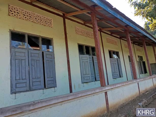
These photos were taken in July 2024, in Ax--- village, Z’Yah Kyi Taung Chaw village tract, Htaw Ta Htoo Township, Taw Oo District. The photos show a window and a room in a hospital that were damaged after an SAC Mi-35 fighter jet dropped four bombs on Ax--- village on July 6th 2024. [Photos: KHRG]
Photo Set: Air strike incidents resulting in death, injuries, destruction, and displacement, from January to December 2024
KHRG has received more than 1,142 photos of the destruction and harm caused by State Administration Council (SAC)[1] air strikes, from January to December 2024, in the seven districts of locally-defined Karen State[2]: Doo Tha Htoo (Thaton), Taw Oo (Toungoo), Kler Lwee Htoo (Nyaunglebin), Mergui-Tavoy, Mu Traw (Hpapun), Dooplaya, and Hpa-an districts. During 2021-June 2024, KHRG recorded 227 air strike incidents in Karen State, which killed at least 168 villagers and injured 249 others. Ninety-three of these incidents took place during January-June 2024 alone.[3]
In 2024, SAC soldiers conducted air strikes in the areas surrounding their army camps, in areas without fighting, and in areas outside of their control. A high number of air strikes were conducted on protected buildings such as those inside the compounds of medical clinics, churches, and schools, as well as villagers’ homes, farms, and plantations. This Photo Set includes 61 of these photos, as evidence of immediate and protracted impacts faced by local villagers in the aftermath of SAC air strikes in Southeast Burma. From the selection, 42 still photographs were taken by local community members trained by KHRG to monitor human rights conditions in their areas, and 19 were taken by local villagers.
Further background reading on the situation on attacks on livelihoods in Southeast Burma/Myanmar can be found in the following KHRG reports:
 ,
, 
The photo on the left was taken in February 2024, while KHRG received the photo on the right on February 29th 2024. Both photos are from Aj---village, Hkay Kyi village tract, Pyu Township special area[10], Kler Lwee Htoo District. These photos show two houses owned by two Aj--- villagers that were burned down by an SAC drone attack on February 17th 2024. [Photo: KHRG/Local villager]
Photo Set: Air strike incidents resulting in death, injuries, destruction, and displacement, from January to December 2024
KHRG has received more than 1,142 photos of the destruction and harm caused by State Administration Council (SAC)[1] air strikes, from January to December 2024, in the seven districts of locally-defined Karen State[2]: Doo Tha Htoo (Thaton), Taw Oo (Toungoo), Kler Lwee Htoo (Nyaunglebin), Mergui-Tavoy, Mu Traw (Hpapun), Dooplaya, and Hpa-an districts. During 2021-June 2024, KHRG recorded 227 air strike incidents in Karen State, which killed at least 168 villagers and injured 249 others. Ninety-three of these incidents took place during January-June 2024 alone.[3]
In 2024, SAC soldiers conducted air strikes in the areas surrounding their army camps, in areas without fighting, and in areas outside of their control. A high number of air strikes were conducted on protected buildings such as those inside the compounds of medical clinics, churches, and schools, as well as villagers’ homes, farms, and plantations. This Photo Set includes 61 of these photos, as evidence of immediate and protracted impacts faced by local villagers in the aftermath of SAC air strikes in Southeast Burma. From the selection, 42 still photographs were taken by local community members trained by KHRG to monitor human rights conditions in their areas, and 19 were taken by local villagers.
Further background reading on the situation on attacks on livelihoods in Southeast Burma/Myanmar can be found in the following KHRG reports:

This photo was taken in May 2024, in Am--- village, Kwee Du Hkaw village tract, Moo Township, Kler Lwee Htoo District. The photo shows the house of a villager in Am--- village, which was destroyed by an SAC air strike that occurred sometime during May 1st to 24th 2024. [Photo: KHRG]
Photo Set: Air strike incidents resulting in death, injuries, destruction, and displacement, from January to December 2024
KHRG has received more than 1,142 photos of the destruction and harm caused by State Administration Council (SAC)[1] air strikes, from January to December 2024, in the seven districts of locally-defined Karen State[2]: Doo Tha Htoo (Thaton), Taw Oo (Toungoo), Kler Lwee Htoo (Nyaunglebin), Mergui-Tavoy, Mu Traw (Hpapun), Dooplaya, and Hpa-an districts. During 2021-June 2024, KHRG recorded 227 air strike incidents in Karen State, which killed at least 168 villagers and injured 249 others. Ninety-three of these incidents took place during January-June 2024 alone.[3]
In 2024, SAC soldiers conducted air strikes in the areas surrounding their army camps, in areas without fighting, and in areas outside of their control. A high number of air strikes were conducted on protected buildings such as those inside the compounds of medical clinics, churches, and schools, as well as villagers’ homes, farms, and plantations. This Photo Set includes 61 of these photos, as evidence of immediate and protracted impacts faced by local villagers in the aftermath of SAC air strikes in Southeast Burma. From the selection, 42 still photographs were taken by local community members trained by KHRG to monitor human rights conditions in their areas, and 19 were taken by local villagers.
Further background reading on the situation on attacks on livelihoods in Southeast Burma/Myanmar can be found in the following KHRG reports:
 ,
,  ,
, 
These photos were taken on April 22nd 2024, in Ak--- and Ai--- villages, P’Deh Kaw village tract, Ler Doh (Kyaukyi) Township, Kler Lwee Htoo District. On April 22nd 2024, eight bombs were dropped from SAC aircraft and a helicopter on Ak--- and Ai--- villages, injuring seven villagers, including children, and killing two other villagers. The two photos in the top row show two villagers who were injured by a bomb dropped. The photo in the bottom row shows a house that was burned down during the attack. [Photos: Local villagers]
Photo Set: Air strike incidents resulting in death, injuries, destruction, and displacement, from January to December 2024
KHRG has received more than 1,142 photos of the destruction and harm caused by State Administration Council (SAC)[1] air strikes, from January to December 2024, in the seven districts of locally-defined Karen State[2]: Doo Tha Htoo (Thaton), Taw Oo (Toungoo), Kler Lwee Htoo (Nyaunglebin), Mergui-Tavoy, Mu Traw (Hpapun), Dooplaya, and Hpa-an districts. During 2021-June 2024, KHRG recorded 227 air strike incidents in Karen State, which killed at least 168 villagers and injured 249 others. Ninety-three of these incidents took place during January-June 2024 alone.[3]
In 2024, SAC soldiers conducted air strikes in the areas surrounding their army camps, in areas without fighting, and in areas outside of their control. A high number of air strikes were conducted on protected buildings such as those inside the compounds of medical clinics, churches, and schools, as well as villagers’ homes, farms, and plantations. This Photo Set includes 61 of these photos, as evidence of immediate and protracted impacts faced by local villagers in the aftermath of SAC air strikes in Southeast Burma. From the selection, 42 still photographs were taken by local community members trained by KHRG to monitor human rights conditions in their areas, and 19 were taken by local villagers.
Further background reading on the situation on attacks on livelihoods in Southeast Burma/Myanmar can be found in the following KHRG reports:

This photo was taken in March 2024. The photo shows villagers from Ao--- village, Paw Klo area, K’Ser Doh Township, Mergui-Tavoy District, as they hid under a bridge after SAC K-8W and Mi-2 fighter jets had conducted air strikes on Ao--- village earlier that day. On March 4th 2024, between 10 and 11 am, SAC fighter jets dropped more than 20 bombs on Way Tah Eh (Myitta) Town and Way Tah Eh area, between K’Ser Doh and Ler Doh Soe townships. Following the attack, on March 6th 2024, an SAC aircraft conducted air reconnaissance in the same area. Due to the air strikes, villagers from twelve villages and from Way Tah Eh Town fled to Dawei Town and to the Thailand border area. Air strikes occurred again on March 12th 2024, in K’Moh Thway area, Ler Doh Soe Township. [Photos: KHRG]
Photo Set: Air strike incidents resulting in death, injuries, destruction, and displacement, from January to December 2024
KHRG has received more than 1,142 photos of the destruction and harm caused by State Administration Council (SAC)[1] air strikes, from January to December 2024, in the seven districts of locally-defined Karen State[2]: Doo Tha Htoo (Thaton), Taw Oo (Toungoo), Kler Lwee Htoo (Nyaunglebin), Mergui-Tavoy, Mu Traw (Hpapun), Dooplaya, and Hpa-an districts. During 2021-June 2024, KHRG recorded 227 air strike incidents in Karen State, which killed at least 168 villagers and injured 249 others. Ninety-three of these incidents took place during January-June 2024 alone.[3]
In 2024, SAC soldiers conducted air strikes in the areas surrounding their army camps, in areas without fighting, and in areas outside of their control. A high number of air strikes were conducted on protected buildings such as those inside the compounds of medical clinics, churches, and schools, as well as villagers’ homes, farms, and plantations. This Photo Set includes 61 of these photos, as evidence of immediate and protracted impacts faced by local villagers in the aftermath of SAC air strikes in Southeast Burma. From the selection, 42 still photographs were taken by local community members trained by KHRG to monitor human rights conditions in their areas, and 19 were taken by local villagers.
Further background reading on the situation on attacks on livelihoods in Southeast Burma/Myanmar can be found in the following KHRG reports:
 ,
, 
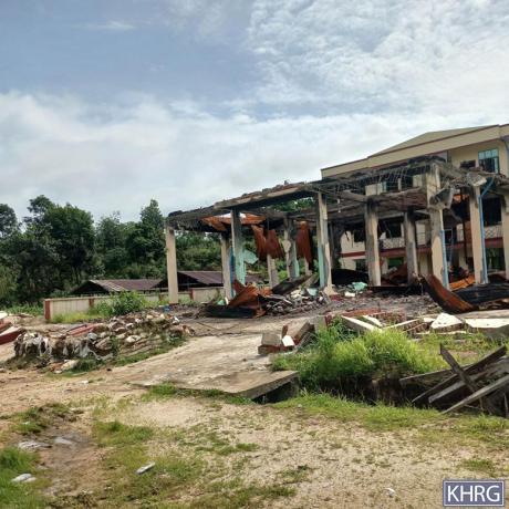
These photos were received from a villager on May 29th 2024, in Ap--- village, K’Ser Doh Township, Mergui-Tavoy District. The photo on the left shows a school that was destroyed by an SAC air strike on May 8th 2024, in Ap--- village. The photo on the right shows a hospital that was destroyed by the same air strike. [Photo: Local villagers]
Photo Set: Air strike incidents resulting in death, injuries, destruction, and displacement, from January to December 2024
KHRG has received more than 1,142 photos of the destruction and harm caused by State Administration Council (SAC)[1] air strikes, from January to December 2024, in the seven districts of locally-defined Karen State[2]: Doo Tha Htoo (Thaton), Taw Oo (Toungoo), Kler Lwee Htoo (Nyaunglebin), Mergui-Tavoy, Mu Traw (Hpapun), Dooplaya, and Hpa-an districts. During 2021-June 2024, KHRG recorded 227 air strike incidents in Karen State, which killed at least 168 villagers and injured 249 others. Ninety-three of these incidents took place during January-June 2024 alone.[3]
In 2024, SAC soldiers conducted air strikes in the areas surrounding their army camps, in areas without fighting, and in areas outside of their control. A high number of air strikes were conducted on protected buildings such as those inside the compounds of medical clinics, churches, and schools, as well as villagers’ homes, farms, and plantations. This Photo Set includes 61 of these photos, as evidence of immediate and protracted impacts faced by local villagers in the aftermath of SAC air strikes in Southeast Burma. From the selection, 42 still photographs were taken by local community members trained by KHRG to monitor human rights conditions in their areas, and 19 were taken by local villagers.
Further background reading on the situation on attacks on livelihoods in Southeast Burma/Myanmar can be found in the following KHRG reports:
 ,
, 
The two photos on the top were taken on August 16th 2024 in As--- village, T’Naw Th’Ree Township, Mergui-Tavoy District. The photo on the left shows an unexploded 500-pound bomb which was dropped by an SAC aircraft on August 15th 2024 in As--- village. The photo on the right shows a community hall that was destroyed by a different 500-pound bomb, which was dropped by an SAC aircraft on the same day. In total, the SAC dropped four 500-pound bombs in As--- village on August 16th 2024, including the unexploded one. [Photos: Local villagers]
Photo Set: Air strike incidents resulting in death, injuries, destruction, and displacement, from January to December 2024
KHRG has received more than 1,142 photos of the destruction and harm caused by State Administration Council (SAC)[1] air strikes, from January to December 2024, in the seven districts of locally-defined Karen State[2]: Doo Tha Htoo (Thaton), Taw Oo (Toungoo), Kler Lwee Htoo (Nyaunglebin), Mergui-Tavoy, Mu Traw (Hpapun), Dooplaya, and Hpa-an districts. During 2021-June 2024, KHRG recorded 227 air strike incidents in Karen State, which killed at least 168 villagers and injured 249 others. Ninety-three of these incidents took place during January-June 2024 alone.[3]
In 2024, SAC soldiers conducted air strikes in the areas surrounding their army camps, in areas without fighting, and in areas outside of their control. A high number of air strikes were conducted on protected buildings such as those inside the compounds of medical clinics, churches, and schools, as well as villagers’ homes, farms, and plantations. This Photo Set includes 61 of these photos, as evidence of immediate and protracted impacts faced by local villagers in the aftermath of SAC air strikes in Southeast Burma. From the selection, 42 still photographs were taken by local community members trained by KHRG to monitor human rights conditions in their areas, and 19 were taken by local villagers.
Further background reading on the situation on attacks on livelihoods in Southeast Burma/Myanmar can be found in the following KHRG reports:
 ,
, 
These two photos were taken in July 2024 in Ar--- village, Kleh Mu Htee area, K’Ser Doh Township, Mergui-Tavoy District. The photos show a villager’s house that was destroyed by an SAC air strike on May 5th 2024. [Photos: KHRG]
Photo Set: Air strike incidents resulting in death, injuries, destruction, and displacement, from January to December 2024
KHRG has received more than 1,142 photos of the destruction and harm caused by State Administration Council (SAC)[1] air strikes, from January to December 2024, in the seven districts of locally-defined Karen State[2]: Doo Tha Htoo (Thaton), Taw Oo (Toungoo), Kler Lwee Htoo (Nyaunglebin), Mergui-Tavoy, Mu Traw (Hpapun), Dooplaya, and Hpa-an districts. During 2021-June 2024, KHRG recorded 227 air strike incidents in Karen State, which killed at least 168 villagers and injured 249 others. Ninety-three of these incidents took place during January-June 2024 alone.[3]
In 2024, SAC soldiers conducted air strikes in the areas surrounding their army camps, in areas without fighting, and in areas outside of their control. A high number of air strikes were conducted on protected buildings such as those inside the compounds of medical clinics, churches, and schools, as well as villagers’ homes, farms, and plantations. This Photo Set includes 61 of these photos, as evidence of immediate and protracted impacts faced by local villagers in the aftermath of SAC air strikes in Southeast Burma. From the selection, 42 still photographs were taken by local community members trained by KHRG to monitor human rights conditions in their areas, and 19 were taken by local villagers.
Further background reading on the situation on attacks on livelihoods in Southeast Burma/Myanmar can be found in the following KHRG reports:
 ,
, 
These photos were taken in July 2024, in Aq--- village, T’Keh village tract, T’Naw Th’Ree (Tanintharyi) Township, Mergui-Tavoy District. The photo on the left shows a house owned by a villager named U[11] C---, which was destroyed by an air strike conducted by an SAC K-8W jet on June 27th 2024. The photo on the right shows the villager’s plantation, which was damaged by the air strike as well. [Photo: KHRG]
Photo Set: Air strike incidents resulting in death, injuries, destruction, and displacement, from January to December 2024
KHRG has received more than 1,142 photos of the destruction and harm caused by State Administration Council (SAC)[1] air strikes, from January to December 2024, in the seven districts of locally-defined Karen State[2]: Doo Tha Htoo (Thaton), Taw Oo (Toungoo), Kler Lwee Htoo (Nyaunglebin), Mergui-Tavoy, Mu Traw (Hpapun), Dooplaya, and Hpa-an districts. During 2021-June 2024, KHRG recorded 227 air strike incidents in Karen State, which killed at least 168 villagers and injured 249 others. Ninety-three of these incidents took place during January-June 2024 alone.[3]
In 2024, SAC soldiers conducted air strikes in the areas surrounding their army camps, in areas without fighting, and in areas outside of their control. A high number of air strikes were conducted on protected buildings such as those inside the compounds of medical clinics, churches, and schools, as well as villagers’ homes, farms, and plantations. This Photo Set includes 61 of these photos, as evidence of immediate and protracted impacts faced by local villagers in the aftermath of SAC air strikes in Southeast Burma. From the selection, 42 still photographs were taken by local community members trained by KHRG to monitor human rights conditions in their areas, and 19 were taken by local villagers.
Further background reading on the situation on attacks on livelihoods in Southeast Burma/Myanmar can be found in the following KHRG reports:

This photo was received on April 1st 2024 from a villager in Ay--- village, Ma Htaw village tract, Dwe Lo Township, Mu Traw District. The photo shows a monk named Saw[12] G--- who was injured on his head after an SAC aircraft dropped a bomb in Ay--- village on March 22nd 2024. [Photo: Local villagers]
Photo Set: Air strike incidents resulting in death, injuries, destruction, and displacement, from January to December 2024
KHRG has received more than 1,142 photos of the destruction and harm caused by State Administration Council (SAC)[1] air strikes, from January to December 2024, in the seven districts of locally-defined Karen State[2]: Doo Tha Htoo (Thaton), Taw Oo (Toungoo), Kler Lwee Htoo (Nyaunglebin), Mergui-Tavoy, Mu Traw (Hpapun), Dooplaya, and Hpa-an districts. During 2021-June 2024, KHRG recorded 227 air strike incidents in Karen State, which killed at least 168 villagers and injured 249 others. Ninety-three of these incidents took place during January-June 2024 alone.[3]
In 2024, SAC soldiers conducted air strikes in the areas surrounding their army camps, in areas without fighting, and in areas outside of their control. A high number of air strikes were conducted on protected buildings such as those inside the compounds of medical clinics, churches, and schools, as well as villagers’ homes, farms, and plantations. This Photo Set includes 61 of these photos, as evidence of immediate and protracted impacts faced by local villagers in the aftermath of SAC air strikes in Southeast Burma. From the selection, 42 still photographs were taken by local community members trained by KHRG to monitor human rights conditions in their areas, and 19 were taken by local villagers.
Further background reading on the situation on attacks on livelihoods in Southeast Burma/Myanmar can be found in the following KHRG reports:

This photo was taken in March 2024 in Section Az--- from Hpapun Town, Dwe Lo Township, Mu Traw District. The photo shows several villagers’ houses that were completely destroyed after SAC fighter jets conducted an air strike on March 24th 2024, in Hpapun area. [Photo: KHRG]
Photo Set: Air strike incidents resulting in death, injuries, destruction, and displacement, from January to December 2024
KHRG has received more than 1,142 photos of the destruction and harm caused by State Administration Council (SAC)[1] air strikes, from January to December 2024, in the seven districts of locally-defined Karen State[2]: Doo Tha Htoo (Thaton), Taw Oo (Toungoo), Kler Lwee Htoo (Nyaunglebin), Mergui-Tavoy, Mu Traw (Hpapun), Dooplaya, and Hpa-an districts. During 2021-June 2024, KHRG recorded 227 air strike incidents in Karen State, which killed at least 168 villagers and injured 249 others. Ninety-three of these incidents took place during January-June 2024 alone.[3]
In 2024, SAC soldiers conducted air strikes in the areas surrounding their army camps, in areas without fighting, and in areas outside of their control. A high number of air strikes were conducted on protected buildings such as those inside the compounds of medical clinics, churches, and schools, as well as villagers’ homes, farms, and plantations. This Photo Set includes 61 of these photos, as evidence of immediate and protracted impacts faced by local villagers in the aftermath of SAC air strikes in Southeast Burma. From the selection, 42 still photographs were taken by local community members trained by KHRG to monitor human rights conditions in their areas, and 19 were taken by local villagers.
Further background reading on the situation on attacks on livelihoods in Southeast Burma/Myanmar can be found in the following KHRG reports:

This photo was taken in March 2024 in Ba--- village, Meh Klaw village tract, Bu Tho Township, Mu Traw District. The photo shows a house owned by a Ba--- villager named Saw H---, which was damaged by an SAC aircraft and drone attack on March 25th 2024. The drone attack also damaged a buffalo shed and a generator and killed villagers’ livestock, including pigs and goats. [Photo: KHRG].
Photo Set: Air strike incidents resulting in death, injuries, destruction, and displacement, from January to December 2024
KHRG has received more than 1,142 photos of the destruction and harm caused by State Administration Council (SAC)[1] air strikes, from January to December 2024, in the seven districts of locally-defined Karen State[2]: Doo Tha Htoo (Thaton), Taw Oo (Toungoo), Kler Lwee Htoo (Nyaunglebin), Mergui-Tavoy, Mu Traw (Hpapun), Dooplaya, and Hpa-an districts. During 2021-June 2024, KHRG recorded 227 air strike incidents in Karen State, which killed at least 168 villagers and injured 249 others. Ninety-three of these incidents took place during January-June 2024 alone.[3]
In 2024, SAC soldiers conducted air strikes in the areas surrounding their army camps, in areas without fighting, and in areas outside of their control. A high number of air strikes were conducted on protected buildings such as those inside the compounds of medical clinics, churches, and schools, as well as villagers’ homes, farms, and plantations. This Photo Set includes 61 of these photos, as evidence of immediate and protracted impacts faced by local villagers in the aftermath of SAC air strikes in Southeast Burma. From the selection, 42 still photographs were taken by local community members trained by KHRG to monitor human rights conditions in their areas, and 19 were taken by local villagers.
Further background reading on the situation on attacks on livelihoods in Southeast Burma/Myanmar can be found in the following KHRG reports:

This photo was taken by villagers on March 26th 2024 in a clinic in Bb--- village, Hkaw Poo village tract, Bu Tho Township, Mu Traw District. On March 26th 2024, at around 6 am, the SAC conducted an air strike on Bb--- village, killing a 37-year-old pregnant woman. The photo shows the four-year-old daughter, who was also injured by the air strike. [Photo: Local villagers]
Photo Set: Air strike incidents resulting in death, injuries, destruction, and displacement, from January to December 2024
KHRG has received more than 1,142 photos of the destruction and harm caused by State Administration Council (SAC)[1] air strikes, from January to December 2024, in the seven districts of locally-defined Karen State[2]: Doo Tha Htoo (Thaton), Taw Oo (Toungoo), Kler Lwee Htoo (Nyaunglebin), Mergui-Tavoy, Mu Traw (Hpapun), Dooplaya, and Hpa-an districts. During 2021-June 2024, KHRG recorded 227 air strike incidents in Karen State, which killed at least 168 villagers and injured 249 others. Ninety-three of these incidents took place during January-June 2024 alone.[3]
In 2024, SAC soldiers conducted air strikes in the areas surrounding their army camps, in areas without fighting, and in areas outside of their control. A high number of air strikes were conducted on protected buildings such as those inside the compounds of medical clinics, churches, and schools, as well as villagers’ homes, farms, and plantations. This Photo Set includes 61 of these photos, as evidence of immediate and protracted impacts faced by local villagers in the aftermath of SAC air strikes in Southeast Burma. From the selection, 42 still photographs were taken by local community members trained by KHRG to monitor human rights conditions in their areas, and 19 were taken by local villagers.
Further background reading on the situation on attacks on livelihoods in Southeast Burma/Myanmar can be found in the following KHRG reports:
 ,
, 
These photos were taken on March 31st 2024. The photo on the right shows villagers tending to the bodies of five of seven villagers who were killed after SAC fighter jets conducted an air strike in Section Az--- of Hpapun Town, Dwe Lo Township, Mu Traw District, on March 31st 2024. The photo on the left shows villagers from Hpapun area leaving the area after the air strike. [Photos: Local villagers]
Photo Set: Air strike incidents resulting in death, injuries, destruction, and displacement, from January to December 2024
KHRG has received more than 1,142 photos of the destruction and harm caused by State Administration Council (SAC)[1] air strikes, from January to December 2024, in the seven districts of locally-defined Karen State[2]: Doo Tha Htoo (Thaton), Taw Oo (Toungoo), Kler Lwee Htoo (Nyaunglebin), Mergui-Tavoy, Mu Traw (Hpapun), Dooplaya, and Hpa-an districts. During 2021-June 2024, KHRG recorded 227 air strike incidents in Karen State, which killed at least 168 villagers and injured 249 others. Ninety-three of these incidents took place during January-June 2024 alone.[3]
In 2024, SAC soldiers conducted air strikes in the areas surrounding their army camps, in areas without fighting, and in areas outside of their control. A high number of air strikes were conducted on protected buildings such as those inside the compounds of medical clinics, churches, and schools, as well as villagers’ homes, farms, and plantations. This Photo Set includes 61 of these photos, as evidence of immediate and protracted impacts faced by local villagers in the aftermath of SAC air strikes in Southeast Burma. From the selection, 42 still photographs were taken by local community members trained by KHRG to monitor human rights conditions in their areas, and 19 were taken by local villagers.
Further background reading on the situation on attacks on livelihoods in Southeast Burma/Myanmar can be found in the following KHRG reports:
 ,
, 
These photos were taken in June 2024 in Bc--- village, Mah Htaw village tract, Dwe Lo Township, Mu Traw District. The photos show two houses owned by villagers, which were destroyed after an SAC aircraft dropped a bomb on Bc--- village on May 28th 2024, at around 11:30 pm. Prior to the attack, KNLA soldiers had carried out drone strikes on the SAC army camp where LIBs #340, #341, and #434 were staying, which is located nearby Bc--- village. [Photos: KHRG]
Photo Set: Air strike incidents resulting in death, injuries, destruction, and displacement, from January to December 2024
KHRG has received more than 1,142 photos of the destruction and harm caused by State Administration Council (SAC)[1] air strikes, from January to December 2024, in the seven districts of locally-defined Karen State[2]: Doo Tha Htoo (Thaton), Taw Oo (Toungoo), Kler Lwee Htoo (Nyaunglebin), Mergui-Tavoy, Mu Traw (Hpapun), Dooplaya, and Hpa-an districts. During 2021-June 2024, KHRG recorded 227 air strike incidents in Karen State, which killed at least 168 villagers and injured 249 others. Ninety-three of these incidents took place during January-June 2024 alone.[3]
In 2024, SAC soldiers conducted air strikes in the areas surrounding their army camps, in areas without fighting, and in areas outside of their control. A high number of air strikes were conducted on protected buildings such as those inside the compounds of medical clinics, churches, and schools, as well as villagers’ homes, farms, and plantations. This Photo Set includes 61 of these photos, as evidence of immediate and protracted impacts faced by local villagers in the aftermath of SAC air strikes in Southeast Burma. From the selection, 42 still photographs were taken by local community members trained by KHRG to monitor human rights conditions in their areas, and 19 were taken by local villagers.
Further background reading on the situation on attacks on livelihoods in Southeast Burma/Myanmar can be found in the following KHRG reports:
 ,
, 
These photos were taken in October 2024 in Bd--- village, Hkaw Poo village tract, Bu Tho Township, Mu Traw District. The photos show two houses owned by villagers that were destroyed by SAC air strikes on October 25th 2024, at 10 am, in Bd--- village. [Photos: KHRG]
Photo Set: Air strike incidents resulting in death, injuries, destruction, and displacement, from January to December 2024
KHRG has received more than 1,142 photos of the destruction and harm caused by State Administration Council (SAC)[1] air strikes, from January to December 2024, in the seven districts of locally-defined Karen State[2]: Doo Tha Htoo (Thaton), Taw Oo (Toungoo), Kler Lwee Htoo (Nyaunglebin), Mergui-Tavoy, Mu Traw (Hpapun), Dooplaya, and Hpa-an districts. During 2021-June 2024, KHRG recorded 227 air strike incidents in Karen State, which killed at least 168 villagers and injured 249 others. Ninety-three of these incidents took place during January-June 2024 alone.[3]
In 2024, SAC soldiers conducted air strikes in the areas surrounding their army camps, in areas without fighting, and in areas outside of their control. A high number of air strikes were conducted on protected buildings such as those inside the compounds of medical clinics, churches, and schools, as well as villagers’ homes, farms, and plantations. This Photo Set includes 61 of these photos, as evidence of immediate and protracted impacts faced by local villagers in the aftermath of SAC air strikes in Southeast Burma. From the selection, 42 still photographs were taken by local community members trained by KHRG to monitor human rights conditions in their areas, and 19 were taken by local villagers.
Further background reading on the situation on attacks on livelihoods in Southeast Burma/Myanmar can be found in the following KHRG reports:

The photo on the left was taken in November 2024 in Be--- village, Nah Hkoh Hkee village tract, Dwe Lo Township, Mu Traw District. The photo shows the spot where a 500-pound bomb dropped by the SAC exploded. The air strike happened on October 30th 2024, at 1 am, in Be--- village. The bomb damaged a wall and the roof of a school in Be--- village, as also seen in the photo. [Photo: KHRG]
Photo Set: Air strike incidents resulting in death, injuries, destruction, and displacement, from January to December 2024
KHRG has received more than 1,142 photos of the destruction and harm caused by State Administration Council (SAC)[1] air strikes, from January to December 2024, in the seven districts of locally-defined Karen State[2]: Doo Tha Htoo (Thaton), Taw Oo (Toungoo), Kler Lwee Htoo (Nyaunglebin), Mergui-Tavoy, Mu Traw (Hpapun), Dooplaya, and Hpa-an districts. During 2021-June 2024, KHRG recorded 227 air strike incidents in Karen State, which killed at least 168 villagers and injured 249 others. Ninety-three of these incidents took place during January-June 2024 alone.[3]
In 2024, SAC soldiers conducted air strikes in the areas surrounding their army camps, in areas without fighting, and in areas outside of their control. A high number of air strikes were conducted on protected buildings such as those inside the compounds of medical clinics, churches, and schools, as well as villagers’ homes, farms, and plantations. This Photo Set includes 61 of these photos, as evidence of immediate and protracted impacts faced by local villagers in the aftermath of SAC air strikes in Southeast Burma. From the selection, 42 still photographs were taken by local community members trained by KHRG to monitor human rights conditions in their areas, and 19 were taken by local villagers.
Further background reading on the situation on attacks on livelihoods in Southeast Burma/Myanmar can be found in the following KHRG reports:
 ,
, 
These two photos were taken in January 2025 in At--- village, K’Ter Tee village tract, Dwe Lo Township, Mu Traw District. The left photo shows an assembly hall, and the right photo shows the glass window of a church that were damaged by an SAC air strike on December 31st 2024, at 4 pm in At--- village. [Photo: KHRG]
Photo Set: Air strike incidents resulting in death, injuries, destruction, and displacement, from January to December 2024
KHRG has received more than 1,142 photos of the destruction and harm caused by State Administration Council (SAC)[1] air strikes, from January to December 2024, in the seven districts of locally-defined Karen State[2]: Doo Tha Htoo (Thaton), Taw Oo (Toungoo), Kler Lwee Htoo (Nyaunglebin), Mergui-Tavoy, Mu Traw (Hpapun), Dooplaya, and Hpa-an districts. During 2021-June 2024, KHRG recorded 227 air strike incidents in Karen State, which killed at least 168 villagers and injured 249 others. Ninety-three of these incidents took place during January-June 2024 alone.[3]
In 2024, SAC soldiers conducted air strikes in the areas surrounding their army camps, in areas without fighting, and in areas outside of their control. A high number of air strikes were conducted on protected buildings such as those inside the compounds of medical clinics, churches, and schools, as well as villagers’ homes, farms, and plantations. This Photo Set includes 61 of these photos, as evidence of immediate and protracted impacts faced by local villagers in the aftermath of SAC air strikes in Southeast Burma. From the selection, 42 still photographs were taken by local community members trained by KHRG to monitor human rights conditions in their areas, and 19 were taken by local villagers.
Further background reading on the situation on attacks on livelihoods in Southeast Burma/Myanmar can be found in the following KHRG reports:

The photo was taken in January 2025 in Au--- village, Lay Hpoe Hta village tract, Dwe Lo Township, Mu Traw District. The photo shows a toilet owned by a villager named Saw D---, which was destroyed after an SAC aircraft conducted an air strike on December 31st 2024, on Au--- village. Several houses owned by villagers were also damaged by the air strike. [Photo: KHRG]
Photo Set: Air strike incidents resulting in death, injuries, destruction, and displacement, from January to December 2024
KHRG has received more than 1,142 photos of the destruction and harm caused by State Administration Council (SAC)[1] air strikes, from January to December 2024, in the seven districts of locally-defined Karen State[2]: Doo Tha Htoo (Thaton), Taw Oo (Toungoo), Kler Lwee Htoo (Nyaunglebin), Mergui-Tavoy, Mu Traw (Hpapun), Dooplaya, and Hpa-an districts. During 2021-June 2024, KHRG recorded 227 air strike incidents in Karen State, which killed at least 168 villagers and injured 249 others. Ninety-three of these incidents took place during January-June 2024 alone.[3]
In 2024, SAC soldiers conducted air strikes in the areas surrounding their army camps, in areas without fighting, and in areas outside of their control. A high number of air strikes were conducted on protected buildings such as those inside the compounds of medical clinics, churches, and schools, as well as villagers’ homes, farms, and plantations. This Photo Set includes 61 of these photos, as evidence of immediate and protracted impacts faced by local villagers in the aftermath of SAC air strikes in Southeast Burma. From the selection, 42 still photographs were taken by local community members trained by KHRG to monitor human rights conditions in their areas, and 19 were taken by local villagers.
Further background reading on the situation on attacks on livelihoods in Southeast Burma/Myanmar can be found in the following KHRG reports:

This photo was taken in January 2025 in Av--- clinic, K’Ter Tee village tract, Dwe Lo Township, Mu Traw District. The photo shows a villager named Saw E--- who was injured by an SAC air strike on December 31st 2024, at 8 pm, in Aw--- village, K’Ter Tee village tract. He sustained the injuries when he returned to his village from a displacement site to check on his house and feed his livestock. He was injured on his wrist, on the left part of his chest, and on the tip of his finger. Furthermore, another villager named Saw I--- was also killed by the air strike on December 31st 2024.[13] [Photo: KHRG]
Photo Set: Air strike incidents resulting in death, injuries, destruction, and displacement, from January to December 2024
KHRG has received more than 1,142 photos of the destruction and harm caused by State Administration Council (SAC)[1] air strikes, from January to December 2024, in the seven districts of locally-defined Karen State[2]: Doo Tha Htoo (Thaton), Taw Oo (Toungoo), Kler Lwee Htoo (Nyaunglebin), Mergui-Tavoy, Mu Traw (Hpapun), Dooplaya, and Hpa-an districts. During 2021-June 2024, KHRG recorded 227 air strike incidents in Karen State, which killed at least 168 villagers and injured 249 others. Ninety-three of these incidents took place during January-June 2024 alone.[3]
In 2024, SAC soldiers conducted air strikes in the areas surrounding their army camps, in areas without fighting, and in areas outside of their control. A high number of air strikes were conducted on protected buildings such as those inside the compounds of medical clinics, churches, and schools, as well as villagers’ homes, farms, and plantations. This Photo Set includes 61 of these photos, as evidence of immediate and protracted impacts faced by local villagers in the aftermath of SAC air strikes in Southeast Burma. From the selection, 42 still photographs were taken by local community members trained by KHRG to monitor human rights conditions in their areas, and 19 were taken by local villagers.
Further background reading on the situation on attacks on livelihoods in Southeast Burma/Myanmar can be found in the following KHRG reports:

This photo was taken in March 2024 in Bf--- village, near Bg--- village, Kaw T’Ree (Kawkareik) Township, Dooplaya District. The photo shows the burnt remains of the houses of villagers after the SAC dropped bombs on Bf--- on March 5th 2024. [Photo: KHRG]
Photo Set: Air strike incidents resulting in death, injuries, destruction, and displacement, from January to December 2024
KHRG has received more than 1,142 photos of the destruction and harm caused by State Administration Council (SAC)[1] air strikes, from January to December 2024, in the seven districts of locally-defined Karen State[2]: Doo Tha Htoo (Thaton), Taw Oo (Toungoo), Kler Lwee Htoo (Nyaunglebin), Mergui-Tavoy, Mu Traw (Hpapun), Dooplaya, and Hpa-an districts. During 2021-June 2024, KHRG recorded 227 air strike incidents in Karen State, which killed at least 168 villagers and injured 249 others. Ninety-three of these incidents took place during January-June 2024 alone.[3]
In 2024, SAC soldiers conducted air strikes in the areas surrounding their army camps, in areas without fighting, and in areas outside of their control. A high number of air strikes were conducted on protected buildings such as those inside the compounds of medical clinics, churches, and schools, as well as villagers’ homes, farms, and plantations. This Photo Set includes 61 of these photos, as evidence of immediate and protracted impacts faced by local villagers in the aftermath of SAC air strikes in Southeast Burma. From the selection, 42 still photographs were taken by local community members trained by KHRG to monitor human rights conditions in their areas, and 19 were taken by local villagers.
Further background reading on the situation on attacks on livelihoods in Southeast Burma/Myanmar can be found in the following KHRG reports:
 ,
, 
These two photos were taken in March 2024 in Bi--- village, Loh Shan village tract, Waw Ray (Win Yay) Township, Dooplaya District. The photos show the roof and front of a house that was damaged by a bomb dropped by an SAC aircraft on March 15th 2024, on Bi--- village. [Photos: KHRG]
Photo Set: Air strike incidents resulting in death, injuries, destruction, and displacement, from January to December 2024
KHRG has received more than 1,142 photos of the destruction and harm caused by State Administration Council (SAC)[1] air strikes, from January to December 2024, in the seven districts of locally-defined Karen State[2]: Doo Tha Htoo (Thaton), Taw Oo (Toungoo), Kler Lwee Htoo (Nyaunglebin), Mergui-Tavoy, Mu Traw (Hpapun), Dooplaya, and Hpa-an districts. During 2021-June 2024, KHRG recorded 227 air strike incidents in Karen State, which killed at least 168 villagers and injured 249 others. Ninety-three of these incidents took place during January-June 2024 alone.[3]
In 2024, SAC soldiers conducted air strikes in the areas surrounding their army camps, in areas without fighting, and in areas outside of their control. A high number of air strikes were conducted on protected buildings such as those inside the compounds of medical clinics, churches, and schools, as well as villagers’ homes, farms, and plantations. This Photo Set includes 61 of these photos, as evidence of immediate and protracted impacts faced by local villagers in the aftermath of SAC air strikes in Southeast Burma. From the selection, 42 still photographs were taken by local community members trained by KHRG to monitor human rights conditions in their areas, and 19 were taken by local villagers.
Further background reading on the situation on attacks on livelihoods in Southeast Burma/Myanmar can be found in the following KHRG reports:

This photo was taken in March 2024 in Bj--- village, Meh Taw village tract, Kaw T’Ree Township, Dooplaya District. It shows a school that was completely destroyed after an SAC aircraft conducted an air strike on March 16th 2024, between 4 pm and 6 pm in Bj--- village. [Photo: KHRG]
Photo Set: Air strike incidents resulting in death, injuries, destruction, and displacement, from January to December 2024
KHRG has received more than 1,142 photos of the destruction and harm caused by State Administration Council (SAC)[1] air strikes, from January to December 2024, in the seven districts of locally-defined Karen State[2]: Doo Tha Htoo (Thaton), Taw Oo (Toungoo), Kler Lwee Htoo (Nyaunglebin), Mergui-Tavoy, Mu Traw (Hpapun), Dooplaya, and Hpa-an districts. During 2021-June 2024, KHRG recorded 227 air strike incidents in Karen State, which killed at least 168 villagers and injured 249 others. Ninety-three of these incidents took place during January-June 2024 alone.[3]
In 2024, SAC soldiers conducted air strikes in the areas surrounding their army camps, in areas without fighting, and in areas outside of their control. A high number of air strikes were conducted on protected buildings such as those inside the compounds of medical clinics, churches, and schools, as well as villagers’ homes, farms, and plantations. This Photo Set includes 61 of these photos, as evidence of immediate and protracted impacts faced by local villagers in the aftermath of SAC air strikes in Southeast Burma. From the selection, 42 still photographs were taken by local community members trained by KHRG to monitor human rights conditions in their areas, and 19 were taken by local villagers.
Further background reading on the situation on attacks on livelihoods in Southeast Burma/Myanmar can be found in the following KHRG reports:
 ,
,  ,
, 
The photos on the top row were taken in March 2024 in Bh--- village, Kyaw Hkee village tract, Kaw T’Ree Township, Dooplaya District. These show two houses owned by a villager that were heavily damaged after SAC aircraft dropped two 500-pound bombs on Bh--- village on March 18th and 19th 2024. The bombs killed one villager. The photo on the bottom left was taken on March 19th 2024 in the same place and shows an unexploded bomb that had been dropped from an SAC aircraft. The photo on the bottom left was received from a villager on March 21st 2024. [Photos: KHRG / Local villagers]
Photo Set: Air strike incidents resulting in death, injuries, destruction, and displacement, from January to December 2024
KHRG has received more than 1,142 photos of the destruction and harm caused by State Administration Council (SAC)[1] air strikes, from January to December 2024, in the seven districts of locally-defined Karen State[2]: Doo Tha Htoo (Thaton), Taw Oo (Toungoo), Kler Lwee Htoo (Nyaunglebin), Mergui-Tavoy, Mu Traw (Hpapun), Dooplaya, and Hpa-an districts. During 2021-June 2024, KHRG recorded 227 air strike incidents in Karen State, which killed at least 168 villagers and injured 249 others. Ninety-three of these incidents took place during January-June 2024 alone.[3]
In 2024, SAC soldiers conducted air strikes in the areas surrounding their army camps, in areas without fighting, and in areas outside of their control. A high number of air strikes were conducted on protected buildings such as those inside the compounds of medical clinics, churches, and schools, as well as villagers’ homes, farms, and plantations. This Photo Set includes 61 of these photos, as evidence of immediate and protracted impacts faced by local villagers in the aftermath of SAC air strikes in Southeast Burma. From the selection, 42 still photographs were taken by local community members trained by KHRG to monitor human rights conditions in their areas, and 19 were taken by local villagers.
Further background reading on the situation on attacks on livelihoods in Southeast Burma/Myanmar can be found in the following KHRG reports:
 ,
, 
These two photos were taken in July 2024 in Bk--- village, Kyauk Kan Koh village tract, Noh T’Kaw (Kyainseikgyi) Township, Dooplaya District. The photo on the left shows the inside of a monastery that was damaged by an SAC air strike on July 19th 2024 in Bk--- village. The photo on the right shows the site of a bomb explosion from the same SAC air strike. The air strike also damaged the monastery's dining hall and injured nearby livestock. [Photos: KHRG]
Photo Set: Air strike incidents resulting in death, injuries, destruction, and displacement, from January to December 2024
KHRG has received more than 1,142 photos of the destruction and harm caused by State Administration Council (SAC)[1] air strikes, from January to December 2024, in the seven districts of locally-defined Karen State[2]: Doo Tha Htoo (Thaton), Taw Oo (Toungoo), Kler Lwee Htoo (Nyaunglebin), Mergui-Tavoy, Mu Traw (Hpapun), Dooplaya, and Hpa-an districts. During 2021-June 2024, KHRG recorded 227 air strike incidents in Karen State, which killed at least 168 villagers and injured 249 others. Ninety-three of these incidents took place during January-June 2024 alone.[3]
In 2024, SAC soldiers conducted air strikes in the areas surrounding their army camps, in areas without fighting, and in areas outside of their control. A high number of air strikes were conducted on protected buildings such as those inside the compounds of medical clinics, churches, and schools, as well as villagers’ homes, farms, and plantations. This Photo Set includes 61 of these photos, as evidence of immediate and protracted impacts faced by local villagers in the aftermath of SAC air strikes in Southeast Burma. From the selection, 42 still photographs were taken by local community members trained by KHRG to monitor human rights conditions in their areas, and 19 were taken by local villagers.
Further background reading on the situation on attacks on livelihoods in Southeast Burma/Myanmar can be found in the following KHRG reports:
 ,
, 
These two photos were received from a villager on March 10th 2024 in BL--- village, Htee Wah Blaw village tract, T’Nay Hsah (Nabu) Township, Hpa-an District. These photos show Bl--- village after an SAC air strike on the village on March 9th 2024. The photo on the left shows the house and tractor of a villager that were both burned to the ground by the air strike. The photo on the right shows another house of a villager that was completely burnt down. In total, the attack burnt down two houses and destroyed all the materials in the houses as well as a sawmill. [Photos: Local villagers]
Photo Set: Air strike incidents resulting in death, injuries, destruction, and displacement, from January to December 2024
KHRG has received more than 1,142 photos of the destruction and harm caused by State Administration Council (SAC)[1] air strikes, from January to December 2024, in the seven districts of locally-defined Karen State[2]: Doo Tha Htoo (Thaton), Taw Oo (Toungoo), Kler Lwee Htoo (Nyaunglebin), Mergui-Tavoy, Mu Traw (Hpapun), Dooplaya, and Hpa-an districts. During 2021-June 2024, KHRG recorded 227 air strike incidents in Karen State, which killed at least 168 villagers and injured 249 others. Ninety-three of these incidents took place during January-June 2024 alone.[3]
In 2024, SAC soldiers conducted air strikes in the areas surrounding their army camps, in areas without fighting, and in areas outside of their control. A high number of air strikes were conducted on protected buildings such as those inside the compounds of medical clinics, churches, and schools, as well as villagers’ homes, farms, and plantations. This Photo Set includes 61 of these photos, as evidence of immediate and protracted impacts faced by local villagers in the aftermath of SAC air strikes in Southeast Burma. From the selection, 42 still photographs were taken by local community members trained by KHRG to monitor human rights conditions in their areas, and 19 were taken by local villagers.
Further background reading on the situation on attacks on livelihoods in Southeast Burma/Myanmar can be found in the following KHRG reports:

This photo was taken in May 2024 in Bm--- village, Way Shan village tract, T’Nay Hsah Township, Hpa-an District. This photo shows the remains of a house that was completely burnt down by an SAC air strike on March 18th 2024, at 5 pm. [Photo: KHRG]
Photo Set: Air strike incidents resulting in death, injuries, destruction, and displacement, from January to December 2024
KHRG has received more than 1,142 photos of the destruction and harm caused by State Administration Council (SAC)[1] air strikes, from January to December 2024, in the seven districts of locally-defined Karen State[2]: Doo Tha Htoo (Thaton), Taw Oo (Toungoo), Kler Lwee Htoo (Nyaunglebin), Mergui-Tavoy, Mu Traw (Hpapun), Dooplaya, and Hpa-an districts. During 2021-June 2024, KHRG recorded 227 air strike incidents in Karen State, which killed at least 168 villagers and injured 249 others. Ninety-three of these incidents took place during January-June 2024 alone.[3]
In 2024, SAC soldiers conducted air strikes in the areas surrounding their army camps, in areas without fighting, and in areas outside of their control. A high number of air strikes were conducted on protected buildings such as those inside the compounds of medical clinics, churches, and schools, as well as villagers’ homes, farms, and plantations. This Photo Set includes 61 of these photos, as evidence of immediate and protracted impacts faced by local villagers in the aftermath of SAC air strikes in Southeast Burma. From the selection, 42 still photographs were taken by local community members trained by KHRG to monitor human rights conditions in their areas, and 19 were taken by local villagers.
Further background reading on the situation on attacks on livelihoods in Southeast Burma/Myanmar can be found in the following KHRG reports: