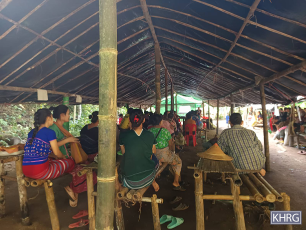
This Photo Set shows photographic evidence from January 2024 to October 2024 of displaced villagers and the conditions they have to endure while internally displaced in Southeast Burma. During this period, KHRG received 1,639 photos of the situation of displacement of villagers in Southeast Burma. This Photo Set includes 57 photographs showing villagers, including children and elderly, from at least 70 villages, who fled their homes, and displays the conditions they faced while sheltering in the jungle, caves, other villages, or in temporary displacement sites. In most cases, villagers fled their homes due to State Administration Council (SAC) attacks in their villages, or in the surroundings. Such attacks in civilian areas seriously impact villagers’ security and livelihoods, as well as their education and access to medical facilities. While displaced, villagers were lacking shelter, food, medicines, proper schooling, and freedom of movement and from fear.
Photo Set: Villagers’ displacement in Southeast Burma, and reported challenges, from January to October 2024
The State Administration Council (SAC)[1]’s constant shelling, air strikes, and firing into and near villages in locally-defined Karen State[2] have resulted in death and injuries for villagers, damaged and destroyed villagers’ properties, and inflicted fear on villagers to live in their homes, forcing them to flee. While displaced, villagers encountered difficulties and challenges to secure their livelihood, and obtain healthcare and education. After leaving their homes, villagers live in caves, small huts, tarpaulin tents, makeshift bunkers, in plantation areas and farmlands, in the jungle, and near river sources. Their struggles increase during the rainy season (July to October). Common sicknesses in displacement areas include fever, colds, and diarrhoea; which mostly remain untreated due to a lack of sufficient medicine or healthcare professionals in remote areas where villagers hide. Villagers also encounter food scarcity during displacement as they are unable to return to their villages due to imposed travel restrictions, ongoing fighting, and risk of attacks. In displacement areas, children endure hardships and have to take risks to continue their studies in small makeshift shelters, lacking necessary materials, and constantly in fear.
Displaced villagers still experience persistent fear due to SAC aircraft conducting air reconnaissance, dropping bombs and firing bullets and shells into villages and their surrounding areas, into plantations, and even into displacement sites.[3] As of November 2024, some of the displaced communities have returned to their villages, however, many are unable to return to their village as their houses and plantations were destroyed by air strikes, drone strikes, shelling and fighting, and due to ongoing risks of SAC attacks.
This photo set includes 57 photos from six out of seven districts in locally-defined Karen State: Doo Tha Htoo (Thaton), Taw Oo (Toungoo), Kler Lwee Htoo (Nyaunglebin), Mergui-Tavoy, Mu Traw (Hpapun), and Dooplaya Districts. These photos were taken between January and October 2024 by local villagers as well as community members who have been trained by KHRG to monitor the human rights situation in their local area.[4] The photographic evidence is presented below and censored where necessary for security purposes. This Photo Set illustrates villagers’ difficulties and challenges related to healthcare, livelihoods and education while being displaced in Southeast Burma.
Further background reading on the situation on displacement in Southeast Burma/Myanmar can be found in the following KHRG reports:
- ကဘီယူၤဟဲလံ Aircraft coming! : Impacts of air strikes on local communities and villagers’ protection strategies in Southeast Burma since the 2021 coup, November 2024.
- Schools Under Attack : Challenges to the right to education in Southeast Burma (June 2023-February 2024), July 2024.
- Striking Fear: Impacts of State Administration Council (SAC) shelling on villagers’ lives in Southeast Burma (January to October 2023), December 2023.
These photos were taken in January 2024 in Aa--- cave, Kaw Ler village tract[5], Tha Htoo Township, Doo Tha Htoo District. These photos show Internally Displaced People (IDPs) from Aa--- village who have been displaced since December 19th 2023, after the SAC conducted shelling that killed a villager named Naw[6] A--- and caused significant destruction in Ab--- village, Kaw Ler village tract. Over one thousand villagers from this village tract fled from their villages in fear. Despite the SAC conducting regular shelling (since December 2023 to January 2024), most of the local villagers initially chose not to leave their houses to protect their properties and livelihoods. They were also reluctant to flee because they wanted to access healthcare and education in the village. Displaced villagers are from Ab---, Ac---, Ad---, Ae--- and Af--- villages. They have been displaced to different places; some villagers fled to the forest and others fled to other villages, to their relatives’ houses, to towns or to their relatives’ houses in Thailand. Villagers in Kaw Ler village tract ordinarily plant rice paddy during winter and summer, but they could not work on the fields or farms or take care of their livestock to secure their family livelihoods due to the ongoing SAC shelling in the area. Some villagers had to sell their livestock at a lower price than the usual local rate and some lost their livestock, houses and other properties during the shelling and were left without access to any compensation or support. Therefore, villagers are worried about their family livelihoods and their future. [7] [Photos: KHRG]
- Thaton (Doo Tha Htoo) District
These photos were taken in January 2024, in Ag--- village, and the surrounding area, in Kaw Ler village tract, Tha Htoo Township, Doo Tha Htoo District. The photo on the left displays the village deserted, after villagers fled. The photo on the right shows bunkers built by villagers to protect themselves outside of the village. On January 10th 2024, SAC Artillery Unit #402, based in Noh Hpa Htaw army camp (in Noh Ta Hsghuh village tract, Tha Htoo Township), shelled into the village, causing villagers to flee and become displaced.[8] [Photos: KHRG]
- Thaton (Doo Tha Htoo) District
These photos were taken in June 2024, at Saw[9] B---’s plantation which is a half mile [0.8 kilometres] from Ah--- village, Day Loh Mu Nu area, Htaw Ta Htoo Township, Taw Oo District. A skirmish happened between SAC troops and People’s Defence Force (PDF)10] soldiers on September 12th 2023 in Ai--- village, Day Loh Mu Nu area. On September 13th 2023, SAC combined troops, including Infantry Battalion (IB)[11] #39, soldiers were patrolling into Ah--- village, Ai--- village and Aj--- village, in Day Loh Mu Nu area. Therefore, villagers from these three villages fled to safe places nearby as they were afraid. Villagers could not access education as they were not able to return to their villages. In order to be able to get an education for their children, parents held a meeting with a village head from Ah--- village, appointed by the Karen National Union (KNU)[12], and the village head discussed this situation with other KNU local authorities. Finally, they built three small buildings on the villager’s plantation where children can safely study, as seen in the photos. [Photos: KHRG]
- Toungoo (Taw Oo) District
These photos were taken in January 2024, at a betel nut[13] plantation field, in Ak--- village, Paw Pee Der village tract, Moo Township, Kler Lwee Htoo District. These photos display shelters built by villagers from Ak--- village and Al--- villages who were displaced in a betel nut plantation field. Villagers had been displaced since Karen National Liberation Army (KNLA)[14] soldiers, combined with PDF soldiers, attacked SAC Light Infantry Battalion (LIB)[15] #590 in nearby Am--- village, Moo Special area, on December 2nd 2023. Villagers remained afraid of fighting and potential attacks on their villages. [Photos: KHRG]
- Nyaunglebin (Kler Lwee Htoo) District
These photos were taken in August 2024, in An--- village, Gyi Yoe village tract, Moo special area, Pyu Township, Kler Lwee Htoo District. These photos show displaced villagers from Ao--- village, Leik Paw village tract, Pyu Township, who were sheltering in An--- village, Gyi Yoe village tract. On August 9th 2024, 60 SAC soldiers from Light Infantry Division (LID)[16] #77, based in Pyu Town, entered Ap--- village and Aq--- village, Moo area, Pyu Township, and fighting happened between KNLA (combined with PDF) and SAC troops. Due to the fighting, the villagers from Pauk Z’Lok village tract, Leik Paw village tract, and Gyi Yoe village tract had to flee from their villages, leaving their houses and animals. Due to heavy raining and flooding, villagers faced serious problems during displacement. [Photos: KHRG]
- Nyaunglebin (Kler Lwee Htoo) District
This photo was taken in January 2024, at Paw Klo big area, K’Ser Doh Township, Mergui-Tavoy District. On January 23rd 2024, KNLA Battalions #12 and #27 and PDF combined forces attacked the SAC army camp of IB #273, in Ar--- village, Paw Klo big area. Villagers fled to other villages and some fled to their plantations, as they feared and worried that shelling and air strikes would be conducted by the SAC into their village. As of February 2024, they returned to live in their village. [Photo: KHRG]
- Mergui-Tavoy District
These photos were received on February 2nd 2024 from a local villager from As--- village, T’Naw Th’Ree Township, Mergui-Tavoy District. The photos display villagers from As--- village, At---village, Au--- village and Av--- village, who fled from their villages. On January 14th and 15th 2024, fighting happened between the PDF and the SAC near these four villages, and following the fighting, the SAC conducted shelling, so villagers were afraid and fled from their villages. On January 31st 2024, the SAC conducted air strikes near these villages and again on February 5th 2024, so villagers were living in fear. Due to shelling and air strikes in the area, the number of displaced villagers increased in T’Naw Th’Ree Township. [Photos: local villager]
- Mergui-Tavoy District
This photo was taken in August 2024 in the jungle, in Th’Kyet village tract, T’Naw Th’Ree Township, Mergui-Tavoy District. On August 15th 2024, the SAC conducted air strikes in Ax--- village, Th’Kyet village tract, so villagers fled from their villages to the jungle. This photo shows villagers during their displacement sheltering under tarpaulins amidst the rainy season. [Photo: KHRG]
- Mergui-Tavoy District
KHRG received these photos on August 17th 2024 from a villager from Ax--- village, T’Keh village tract, T’Naw Th’Ree Township, Mergui-Tavoy District. These photos show villagers who were displaced due to SAC air strikes conducted on August 15th 2024 into Ax--- village. Villagers from Ay---, Az---, and Ba--- villages, all in T’Keh village tract, also fled. Students had to stop going to school due to the air strikes. Roads from Bb--- village, in Kleh Mu Htee area, were closed by the SAC and villagers faced difficulties due to travel restrictions. There were elderly villagers and mothers who had recently given birth among the displaced, particularly in need of food and medicine for various ailments. [Photos: Local villager]
- Mergui-Tavoy District
KHRG received this photo on October 22nd 2024, from a villager in Pah Pyin village tract, Ler Muh Ler Township, Mergui-Tavoy District. In October 2024, fighting happened between KNLA and SAC soldiers near Bc--- village, Pah Pyin village tract, Ler Muh Lar Township, Mergui-Tavoy District, so villagers from Bc--- village, fled to the jungle. During displacement, villagers faced food shortages. Villagers had to flee when fighting happened and returned to their village only when the situation was getting better. [Photo: Local villager]
- Mergui-Tavoy District
These photos were taken in March 2024, in the jungle near Baw Thay Hta village tract, Lu Thaw Township, Mu Traw District. These photos show displaced villagers from Bd--- village, Be--- village, and Bf--- village, Baw Thay Hta village tract who fled to the jungle and near river sources after the SAC conducted shelling and air strikes in the area. From March 19th until March 25th, the SAC conducted air strikes and drone strikes into villages and plantations almost every day. There were 1,254 people from these three villages who were displaced. The displaced villagers faced food shortages and a lack of tarpaulins for sheltering. Moreover, villagers faced health problems such as fever, coughing, sneezing, and diarrhoea. Health workers tried to look after the displaced villagers but they did not have enough medicine. [Photos: KHRG]
- Hpapun (Mutraw) District
This photo was taken in March 2024, in Bn--- village, Mah Htaw village tract, Dwe Lo Township, Mu Traw District, following a drone strike. On March 22nd 2024, the SAC conducted drone strikes into Bm--- monastery, Bn--- village, and injured a monk named U[17] C--- on the back of his head. He was sent to Chiang Mai province (Thailand) for treatment. [Photo: KHRG]
- Hpapun (Mutraw) District
These photos were taken in March 2024, at Bo--- jungle, near Bp--- village, Meh Nyuh village tract, Bu Tho Township, Mu Traw District. These photos show villagers from Bp--- village who fled to the jungle and had to live in the temporary huts that they built due to SAC shelling. [Photos: KHRG]
- Hpapun (Mutraw) District
These photos were taken in March 2024, at Bq--- place near Br--- village, Meh Nyuh village tract, Bu Tho Township. These photos show displaced villagers from Bp--- village, Meh Nyuh village tract, who were hiding from SAC air strikes in a bunker. On March 15th 2024, KNLA combined with PDF troops attacked an SAC military camp in Pah Pu Town, Bu Tho Township. Following the attacks, SAC aircraft patrolled over area and conducted air strikes in an area 20 miles (32 kilometres) far from the town, so villagers were afraid and fled to the jungle. [Photos: KHRG]
- Hpapun (Mutraw) District
These photos were taken in March 2024, in Bu--- displacement site, near Bp--- village, Meh Nyuh village tract, Bu Tho Township, Mu Traw District. These photos show displaced villagers making a roof out of leaves to build temporary huts during displacement. On March 28th 2024, SAC conducted air strikes in Meh Nyuh village tract so the villagers from Meh Nyuh village tract had to flee to jungle. [Photo: KHRG]
- Hpapun (Mutraw) District
KHRG received these photos on April 4th 2024 from a villager in Bg--- Town, Lu Thaw Township, Mu Traw District. On March 31st 2024, the SAC conducted air strikes in Bg--- Town, onto Bh--- temple, where displaced villagers were sheltered in, and killed seven villagers and injured nine more, including children. Six villagers were killed immediately, and one of them was injured severely, so people tried to send him to a Thai hospital, but he passed away when he arrived in Thailand. [Photos: Local villager]
- Hpapun (Mutraw) District
A villager took these photos on March 31st 2024 in the jungle outside Bg--- Town, Lu Thaw Township, Mu Traw District. These photos show displaced villagers receiving treatment from healthcare workers [name of organisation censored for security] after the SAC air strikes conducted in Bg--- Town, on Bh--- temple, that same day. Nine people were injured, including children, because of the SAC air strikes, and seven villagers died. [Photos: Local villager]
- Hpapun (Mutraw) District
These photos were taken in April 2024 on a trench in a jungle near Bj--- village, Ma Taw village tract, Dwe Lo Township, Mu Traw District. Villagers use this place to hide from SAC shelling and air strikes. On April 3rd 2024, around 7 am, the SAC conducted mortar shelling in Bj--- village, and a villager named Saw D--- (60 years old) was injured by shrapnel on his back, lips and left hand. On that day, he was sent to Bk--- clinic, Pay Kay village tract, Lu Thaw Township, to get treatment. He was looked after in Bl--- temporary healthcare shelter before he was moved to Bk--- clinic. [Photos: KHRG]
- Hpapun (Mutraw) District
These photos were taken in July 2024, in Bs--- displacement site, Hkaw Pu village tract, Bu Tho Township, Mu Traw District. In 2024, the conflict between KNLA combined with PDF and SAC increased in Hkaw Pu village tract, so Bt--- villagers had to flee from their village to Bs--- displacement site. These photos show students learning in a school that was built by displaced villagers in the displacement site. [Photos: KHRG]
- Hpapun (Mutraw) District
These photos were taken in January 2024, in Bv--- village, Kyaw Hta village tract, Kaw T’Ree Township, Dooplaya District. These photos show villagers from Bw--- village, Meh Naw Aa village tract, Kaw T’Ree Township, who sought shelter in By--- village due to fighting that occurred in Kyeh Done Town on January 26th 2024 between KNLA and SAC solders. [Photos: KHRG]
- Dooplaya District
These pictures were taken in March 2024 and show an ‘emergency clinic’ in Zz--- displacement site, near By--- village, Thay Baw Boh village tract, Kaw T’Ree Township, Dooplaya District. The clinic was established in December 2021 by displaced villagers, after fighting broke out between SAC armed forces and armed resistance groups in Bz--- village, Lay Kay Kaw village tract, Kaw T’Ree Township. There are more than 100 households sheltering in By--- village’s displacement site, Zz----. The clinic provides free health care treatment with medical supplies provided by the Karen Department of Health and Welfare (KDHW)[18]. If the clinic cannot treat the patients, villagers are referred to Ca--- hospital, located in Thailand’s Tak province. [Photos: KHRG]
- Dooplaya District
These photos were taken in March 2024 at Ck--- village, Poe Yay village tract, Kaw T’Ree Township, Dooplaya District. On February 23rd 2023, Burma Army soldiers conducted air strike into Ck--- village, damaging villages’ houses and properties. In addition, villagers were forced to flee to other villages. Some villages returned to the village to check their properties. When villagers returned to their houses and saw an aircraft flying over the village, they took cover inside makeshift bunkers. [Photos: KHRG]
- Dooplaya District
These photos were taken in March2024 in Kyaw Hta village tract, Kaw T’Ree Township, Dooplaya District On March 16th 2024, the SAC conducted air strikes into Cb--- village, Kyaw Hta village tract, killing two villagers, injuring one villager, and damaging villagers’ houses. After the air strikes, the villagers were afraid and fled to caves, riverbanks and the jungle. The two photos on the top row and the photo on the bottom left show villagers from Cb--- village and nearby Cc--- village, Kyaw Hta village tract, who were hiding in Cd--- cave. The photo on the bottom right shows villagers sheltering on a riverbank. The displaced villagers encountered challenges in securing food and accessing healthcare, and they are in need of support. [Photos: KHRG]
- Dooplaya District
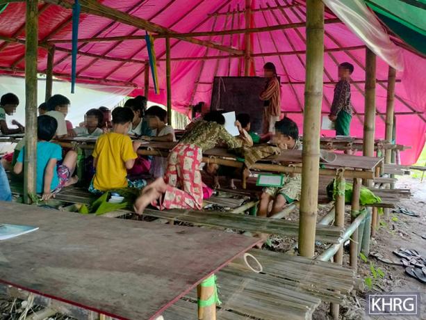
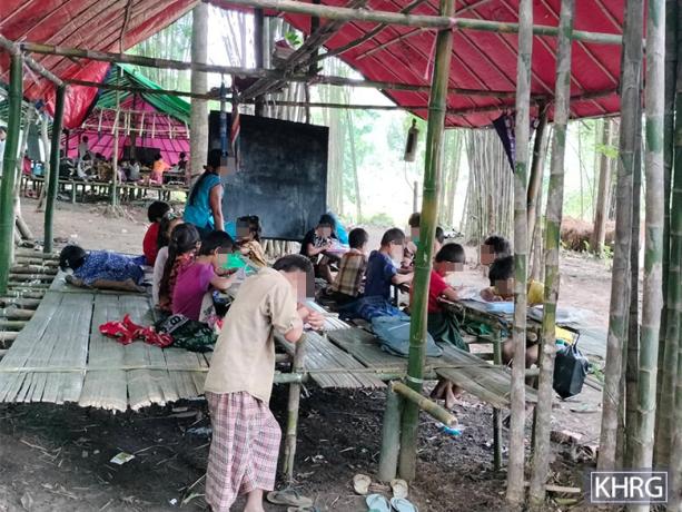
These photos were taken in September 2024, at Cf--- village, Noh Poe village tract, Kaw T’Ree Township, Dooplaya District. They show displaced villagers from Cg--- village, Noh Poe village tract, sheltering in makeshift houses built by displaced villagers due to SAC shelling. The two photos on the bottom show a learning place for children. There were around 40 households displaced, including three women who had recently given birth, many children, and one elderly. [Photos: KHRG]
- Dooplaya District
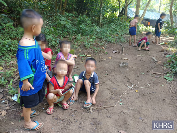
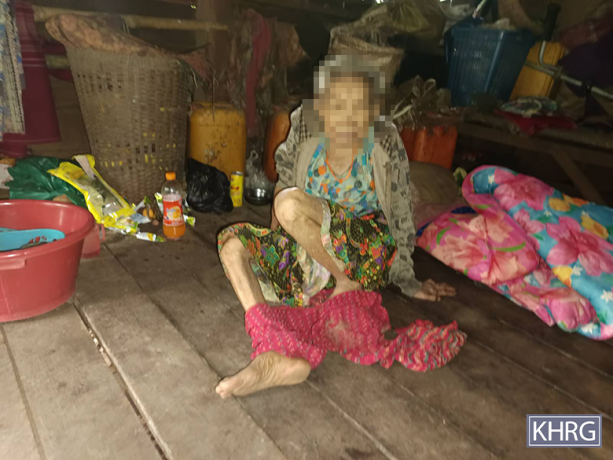
These photos were taken in October 2024, in Ch--- and Ci--- villages, Noh Poe village tract, Kaw T’Ree Township, Dooplaya District. These photos show villagers from Cj--- village who fled to the jungle because they were afraid to stay in their village due to SAC shelling and air strikes. Children cannot attend school in the village, so they had to attend school at Ci--- school, located in Noh Poe village tract. The photo on the bottom left shows children playing in the jungle during displacement. The first picture (top left) display an elderly sitting inside a hut, and the two photos on the right show displaced villagers gathering in Ci--- village. [Photos: KHRG]
- Dooplaya District
Footnotes:
[1] The State Administration Council (SAC) is the executive governing body created in the aftermath of the February 1st 2021 military coup. It was established by Senior General Min Aung Hlaing on February 2nd 2021, and is composed of eight military officers and eight civilians. The chairperson serves as the de facto head of government of Burma/Myanmar and leads the Military Cabinet of Myanmar, the executive branch of the government. Min Aung Hlaing assumed the role of SAC chairperson following the coup.
[2] Karen State, defined locally, includes the following areas: Kayin State, Tanintharyi Region and parts of Mon State and Bago Region. Karen State, located in Southeastern Burma, is primarily inhabited by ethnic Karen people. Most of the Karen population resides in the largely rural areas of Southeast Burma, living alongside other ethnic groups, including Bamar, Shan, Mon and Pa’Oh.
[3] KHRG, ကဘီယူၤဟဲလံ Aircraft coming! : Impacts of air strikes on local communities and villagers’ protection strategies in Southeast Burma since the 2021 coup, November 2024, pp. 51-59.
[4] KHRG operates in seven areas in Southeast Burma: Doo Tha Htoo (Thaton), Taw Oo (Toungoo), Kler Lwee Htoo (Nyaunglebin), Mergui-Tavoy, Mu Traw (Hpapun) and Dooplaya and Hpa-an. When KHRG receives information from the field, it organises data according to these seven areas. These are commonly referred to as ‘districts’ and are used by the Karen National Union (KNU), as well as many local Karen organisations, both those affiliated and unaffiliated with the KNU. KHRG’s use of the district designations in reference to our research areas does not imply political affiliation; rather, it is rooted in the fact that many rural communities commonly use these designations. For clarity, the Burmese terms for these districts are provided in brackets but do not correspond with the Burma (Myanmar) government administrative divisions.
[5] A village tract is an administrative unit of between five and 20 villages in a local area, often centred on a large village.
[6] ‘Naw’ is a female honorific title in S’Gaw Karen language used before a person’s name.
[7] KHRG, “Doo Tha Htoo District Situation Update: SAC shelling causing casualties and displacement, travel restrictions, and livelihood, education and healthcare challenges, in Tha Htoo Township (December 2023 to January 2024)”, May 2024.
[8] KHRG, “Doo Tha Htoo District Situation Update: SAC shelling causing casualties and displacement, travel restrictions, and livelihood, education and healthcare challenges, in Tha Htoo Township (December 2023 to January 2024)”, May 2024.
[9] ‘Saw’ is a S’gaw Karen male honorific title used before a person’s name.
[10] The People’s Defence Force (PDF) is an armed resistance established independently as local civilian militias operating across the country. Following the February 1st 2021 military coup and the ongoing brutal violence enacted by the junta, the majority of these groups began working with the National Unity Government (NUG), a body claiming to be the legitimate government of Burma (Myanmar), which then formalised the PDF on May 5th 2021 as a precursor to a federal army.
[11] An Infantry Battalion (IB) comprises 500 soldiers. However, most Infantry Battalions in the Tatmadaw are under-strength with less than 200 soldiers. Yet up to date information regarding the size of battalions is hard to come by, particularly following the signing of the NCA. They are primarily used for garrison duty but are sometimes used in offensive operations.
[12] The Karen National Union (KNU) is the main Karen political organisation. It was established in 1947 and has been in conflict with the government since 1949. The KNU wields power across large areas of Southeast Myanmar and has been calling for the creation of a democratic federal system since 1976. Although it signed the Nationwide Ceasefire Agreement (NCA) in 2015, following the 2021 coup staged by Burma Army leaders, the KNU officially stated that the NCA has become void.
[13] In Burmese, ‘betel nut’ and ‘betel leaf’ are referred to as konywet and konthih, respectively, as if they are from the same plant. The Burmese names are also commonly used by Karen language speakers. Betel nut is the seed from an areca palm tree, Areca catechu; "betel leaf" is the leaf of the piper betel vine, belonging to the Piperaceae family.
[14] The Karen National Liberation Army is the armed wing of the KNU.
[15] A Light Infantry Battalion (LIB) comprises 500 soldiers. Most Light Infantry Battalions in the Tatmadaw (or Burma Army) are under-strength with less than 200 soldiers, yet up-to-date information regarding the size of battalions is hard to come by, particularly following the signing of the National Ceasefire Agreement (NCA). LIBs are primarily used for offensive operations, but they are sometimes used for garrison duties.
[16] A Light Infantry Division (LID) of the Burma military is commanded by a brigadier general, and consists of ten light infantry battalions specially trained in counter-insurgency, jungle warfare, search and destroy operations against ethnic insurgents. They were first incorporated into the Burma military in 1966. LIDs are organised under three Tactical Operations Commands, commanded by a colonel, three battalions each and one reserve, one field artillery battalion, one armoured squad.
[17] ‘U’ is a Burmese title used for elder men, used before their name.
[18] The Karen Department of Health and Welfare (KDHW) is the health department of the Karen National Union. It was established in 1956 to address the lack of public healthcare resources in rural Southeast Myanmar. It currently operates a network of community-based clinics in the region, but its capabilities remain limited due to funding constraints.


